Canada’s Bay Of Fundy—Home to the World’s Greatest Tides
 ©Bert Gildart: In the entire world, there is no place that produces a greater difference between high tide and low tide than Canada’s Bay of Fundy in New Brunswick. The effects are immediately obvious and influence villagers along a several hundred mile stretch of coast that begins at the mouth of Fundy Bay. From here, the effects increase in drama the further up the bay that one progresses.
At the moment, we’re camped in a forest of red spruce and fir—surrounded by old covered bridges and sweeping seashores that celebrates these tides; it’s called Fundy National Park. As well, we’re not far from the little fishing village of Alma, which claims to be one of the locations where these extraordinary tides are particularly dramatic.
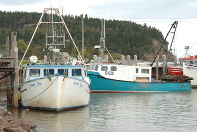
If nothing else, because the village is a fishing village with boats galore, the drama of watching the rise and fall of these boats during any six hour period of time, is extraordinary. In fact, when we first arrived here several days ago, we were so fascinated by the surge of water, that we remained transfixed for almost one entire cycle, simply waiting to see the contrast.
And now that we’ve discovered an Internet connection at Alma’s Activity Center, we can tell you a little about several of the many areas that must conform to the phenomenon of tides that may vary over 50 feet in a span of just a few short hours. Everyone in the park and the village knows the story, and in part we’ve learned about it anecdotally, as well as from museums in the park and in several nearby villages.
 “Everyone knows and understands these variations,” said an Alma fisherman whose access—and livelihood—to nearby lobster waters, must sync with the tremendous variations. “When we use our boats, we have to know when to go and when to return—and when to put out the braces that will keep our boats from flopping. Tides affect the safety of our boats and we have to understand these waters.”
Tides, of course, are created by the alignment of the sun, moon and earth and the gravitational forces these spheres create. When the earth and moon are appropriately aligned, the moon pulls the water up and away from the ocean’s surface, creating in most places high tides that may very but a few feet. But not here in Fundy Bay where Nova Scotia and New Brunswick are aligned to create an immense bay that quickly progresses from a wide mouth to a narrow closure.
Naturalists liken the bay to a huge bathtub in which a rocking motion has been set in place. As high tide increases, so does the rocking motion of the water. At the head of Fundy Bay the narrow stricture builds on the water’s rocking motion, causing the water to climb higher, creating the enormous tides, such as those found near us now in Fundy Park—and nearby Alma.
Because of these enormous tides, people who derive their living from the ocean or from activities associated with the ocean, must plan their activities carefully—and build their works appropriately.
Commercial fishermen in Alma, for instance, must have some the world’s highest wharfs to which they must then attach their boats (at high tide, of course) with what must be some of the world’s longest cinch lines.
 Others, too, are dramatically affected. Alan Moore of Fresh Air Adventures must plan all of his kayak outings on the tides, most specifically the high tides. Alan offers tours up to six hours long, and one of them takes you about 5 miles down the sea side of Fundy Park and into a stream outlet where a covered bridge still provides access to Point Wolfe, site of an old ship-building location. To prevent being stranded, Moore must select his day’s outing to this particular destination so that it takes place over a very specific five hour period. That period is almost precisely 2 ½ hours before high tide and 2 ½ hours after high tide.
“My guides carry all of our rental boats for our customers,” said Alan, “and if our timing is off, it means that someone is going to be trudging through mud that could extend out almost half a mile.”
A little of that is shown in our photograph of stairs descending onto Point Wolfe, which was once a site of massive ship building.
The consequence of not planning one’s outing appropriately has been dramatized in Fundy Bay National Park, and en route to Point Wolfe, Alan’s kayak trips take you by Hunt’s Hole, named for a settler who failed to watch the tides. Surging tides forced the man against a sheer cliff, but the tide tore him loose sucked him through Hunt’s Hole, the hole that now bears his name. As the story goes, Hunt bobbed up on the other side of the hole, but minus his side whiskers and his home spun breeches. Others have not been quite so lucky.
Yesterday, we saw what may probably be the most dramatic effects of Fundy’s tides at the Hopewell Rocks. Here, water covers the rocks twice a day, but they are also exposed twice a day and for periods of about five hours. By now we’d acquired a tide chart and had figured out the times to visit and not to visit areas influenced by tides.
 Yesterday, about two hours before low tide, we descended a series of about 50 steps and then stepped out onto the bottom of the ocean floor. For several hours we walked among these rocks created by exceptionally high tides. One series of rocks was called the Flowerpot Rocks, apparently because of the shrubs and small trees sprouting from the domes of these giant “sea stacks.”
Here is also a safe place to watch the surging tide, for this small park posts an attendant who whisks visitors off the beach when tides begin to surge. But not so soon, that I couldn’t post myself on a small rock and photograph the tide as it began to envelope me. Because my return route to the access steps was in a recess shaped a little like a thumb, this was a relatively safe place to observe the phenomena. To contrast the situation, the day before we had visited Cape Enrage, and here the reverse had been the case. Here a sheer faced cliff undulated in and out, and if the water catches you between the recesses of outward projections, you could easily be trapped.
Bay of Fundy is another of those areas that tends to blow holes into our schedule. It’s fascinating, but, still, we’ll be pulling ourselves loose and heading to Nova Scotia where we’ll be driving the Cabot Trail and then, a week or so later, the Evangeline Trail.


September 16th, 2006 at 11:36 am
Just met Bert at the internet access center so went onto his blog to see some of the great photos he posted. Alma is a beautifull spot
and all our tourist get the tide explanations
the how and why we do have the highest tides.
Good luck Bert and happy travels.
Kirstin
Manager of the access center