Favorite Travel Quotes

"Travel is fatal to prejudice, bigotry, and narrow-mindedness, and many of our people need it sorely on these accounts."
-- Mark Twain
Innocents Abroad

"Stop worrying about the potholes in the road and celebrate the journey." -- Fitzhugh Mullan

"A good traveler has no fixed plans and is not intent on arriving." -- Lao Tzu

Archive for the 'Biking' Category

Intrepid Biker

posted: August 9th, 2018 | by:Bert

INTREPID BIKER: Always enjoy meeting people traveling extensively, particularly by bike. Here’s Richard, a man I meet several days ago in Kalispell, Montana, who has been traveling AROUND the U.S. for almost 20 years, living quite comfortably off what his bike can accommodate. That means Richard carries panniers, a small day pack — and across his chest a tripod secured in a carrying case.

Richard says he has few expenses other than health insurance and that he has never encountered any problems. He said he’s had to modify his life style just a bit, and no longer reads obituaries. I told him how old I was and he said he was one year younger. That means we’re both young men.

30767 Richard (1 of 1) 12084

Janie biking a small portion of the C&O Canal near Harper’s Ferry; intrepid adventurer,
who has been experiencing America by bike for over 20 years. Now operated by
the NPS, men and women interpret the hayday and purpose of he old C&O Canal. Essentially, it is now a bicycle path.


Occasionally, Richard says he’ll push his bike onto a train, and that sounds like an ideal example to follow to fulfill a trip that has been on my bucket list, if, of course, I’m still in good health next year. I plan to be. One year from this September I want to peddle from Pittsburg on a new bike trail to Fredrick, Md, then link with the interconnecting C&O Canal that continues on to Wash, D.C. It’s all rails to trails so no worry about vehicles. I’ll carry a tent, but generally intend to stay in B&Bs which flank the two trails. The area is loaded with history and passes near Gettysburg and also near Harper’s Ferry. Of course I want company, so will be putting pressure on Janie. She always likes my ideas — once she gets into them. My daughter and son-in-law also say they’d like to make this trip.

Anyone actually made this ride? It’s 350 miles and I expect travel time will be about two weeks. Richard said he’d ridden a portion of the C&O, and I have too — a short portion that is, and that was about 30 years ago. Oh, and then just 10 years ago, Janie and I rode a very short portion easily accessed from near Harper’s Ferry.

Generally, the route is level, and passes over a hard dirt trail that parallels an old canal once used by farmers to transport goods to D.C.

I really want to fulfill this long-held dream.


———–


THIS TIME ELEVEN YEARS AGO:

Faces From Our Mount Rainier Climb


Read Comments | Comments Off

Glacier As it Once Was — Experienced by Biking

posted: June 16th, 2018 | by:Bert

GLACIER AS IT ONCE WAS: Each year while snow plows work to clear the Going-to-the-Sun Road the segment between Avalanche Creek and Logan Pass is open to bikers only.

What that means is that bike riders get a chance to see one of the most beautiful places in the world without having to cope with the hordes of visitors Glacier National Park will soon experience. That means if you are a rider, you can stop anywhere you want and that you won’t be surrounded by barking dogs, children and adults screaming, or motorcyclists reeving their unmuffled Harley Davidsons.

What you’ve got NOW approaches a spiritual experience, and I can testify that since arriving in Glacier in 1960 you’ve got Bird Woman Falls still cascading down Mount Cannon after all these years. Then there’s Heaven’s Peak, and dozens of other glacier-influenced peaks.


BikingLoganPass-3

This 78-year old man worked and worked
to properly condition himself for the challenging ascent to Logan Pass, elevation 6646.  Who could it be?


To enjoy these settings, of course you must be in shape, for the 32-mile round trip ride is 3,259 feet up. Put in other words, that’s 16 miles up and 16 miles down. In short, the ride is a challenge and throughout the year I work hard to maintain the fitness required to make the trip. I believe that anyone who really wants to enjoy nature in this manner can work hard and do the same. I made this ride June 12, 2018.

There are, of course, different ways to make the ride. Some tuck in their chins, look straight ahead make the climb in 59 minutes. That speed data is provided by my Garmin, which also tells me when my heart rate exceeds 150, the level my doctor tells me I should not exceed for more than a few minutes. I adhere to his advice, stopping to rest when I’m over the limit.

For comparative purposes, I’m slow and this year I took 3 hours and 59 minutes, but for me that was just perfect. Also, my objectives were different. When I ride I want to look around, enjoy the bighorn sheep I saw grazing near Weeping Wall; marvel at the two black bears that scampered up a tree on my approach; and visit with a few other riders who share my passion of seeing the park before Flathead Valley was discovered – and destroyed. After the road opens for vehicular traffic, believe me, you won’t be able to find a parking place at Logan Pass after 9 a.m. Soon it will literally be bumper to bumper traffic.


BikingLoganPass-5 BikingLoganPass-2 BikingLoganPass-4

Many try to make the ride from Avalanche Creek Campground, forgetting
that you must be properly conditioned.  Success then is certainly a time
for a jubilee.  Just look at the scenery, to include Bird Woman Falls as depicted in center photo.

For me, visiting with the younger crowd also offered a very ego boosting component. In a joking way I told them I was ashamed they were passing me, as I probably had 55 more years of experience than they did. Knowing then that I was on the dark side of my 70’s, the group of four greeted me at Logan Pass with cheers. They pointed their thumbs up and then pumped the thin alpine air that you find at this 6646 foot-high pass, also a part of the Continental Divide.

Though it took almost four hours to make the 16-mile climb, I was back at my truck in little more than an hour — coasting much of the way at speeds up to 25 mph. Turning on my Sirius, I changed the station from Blue Grass to Opera. The station was playing The Blue Danube Waltz, and for a while vivid memories of the way Glacier used to be danced before me. I was thankful that I was able to relive those moments if only for about six hours.

——————————————

THIS TIME LAST YEAR: In Glacier Bikes Should Prevail
(See this post from last year for map of the ride I made this this year.)


4th ed. Autographed by the Authors

Hiking Shenandoah National Park

Hiking Shenandoah National Park is the 4th edition of a favorite guide book, created by Bert & Janie, a professional husband-wife journalism team. Lots of updates including more waterfall trails, updated descriptions of confusing trail junctions, and new color photographs. New text describes more of the park’s compelling natural history. Often the descriptions are personal as the Gildarts have hiked virtually every single park trail, sometimes repeatedly.

$18.95 + Autographed Copy


Big Sky Country is beautiful

Montana Icons: 50 Classic Symbols of the Treasure State

Montana Icons is a book for lovers of the western vista. Features photographs of fifty famous landmarks from what many call the “Last Best Place.” The book will make you feel homesick for Montana even if you already live here. Bert Gildart’s varied careers in Montana (Bus driver on an Indian reservation, a teacher, backcountry ranger, as well as a newspaper reporter, and photographer) have given him a special view of Montana, which he shares in this book. Share the view; click here.

$16.95 + Autographed Copy


What makes Glacier, Glacier?

Glacier Icons: 50 Classic Views of the Crown of the Continent

Glacier Icons: What makes Glacier Park so special? In this book you can discover the story behind fifty of this park’s most amazing features. With this entertaining collection of photos, anecdotes and little known facts, Bert Gildart will be your backcountry guide. A former Glacier backcountry ranger turned writer/photographer, his hundreds of stories and images have appeared in literally dozens of periodicals including Time/Life, Smithsonian, and Field & Stream. Take a look at Glacier Icons

$16.95 + Autographed Copy


Read Comments | Comments Off

In Glacier Bikes Should Prevail

posted: June 27th, 2017 | by:Bert

©Bert Gildart:  Saturday, June 26th, I rode my bike through what is some of the world’s most spectacular country, and I did it on a day when it is safe to do so. Each year, the Glacier National Park road crew must plow the Going to the Sun Road (GTSR) before vehicular traffic can pass through. At a certain point park managers allow bikers to use the road but prohibit vehicles, and it is this period that so many of us look forward to. In fact, many of us wish the park would follow the lead of Grand Canyon and Zion. In those parks summer traffic had gotten so dense that they implemented shuttle service while simultaneously permitting bikers. I like the idea because summers in Glacier have become an absolute madhouse. Finding parking at the many pull overs and, too, at Logan Pass is an impossibility for traffic to Logan Pass is always bumper to bumper.


GNP-Bike-12

One of the best years for Weeping Wall, a Glacier Icon


I arrived at the Avalanche Creek parking lot — the spot along the (GTSR) where drivers must now stop — about 8 Saturday morning, and already that lot was getting full. But I quickly left that scene behind and began my 15 mile ascent to Logan Pass. Yes, there were lots of others riders but the distance between us increased as we began ascending the road. Most everyone passed me, and I told several who joked that, yes, I was ashamed to be left behind — because I probably had 50 years more experience than most other riders. But not all, and there were a number of oldermen and older women who were pumping right along.


Biking-15 LoganPass1

Heavens Peak Overlook back dropped by its namesake,
a mountain I climbed many years ago; approaching Logan Pass


I stopped often to take photographs and sometimes, simply to marvel. Waterfalls were running hard and heavy and when I reach Weeping Wall I stopped and plopped down on the cement retaining wall and ate lunch, realizing that in several weeks such quiet pleasure would be impossible. Mounting my bike again I soon began encountering some of the huge snow banks created by this past winter’s heavy storms.


MapOfRideToLP

On Saturday, June 24, the most distant point a person can drive is Avalanche Lake parking lot,
shown in green arrow. From here one must ride, and what a pleasure it was to be free of
the mountain of summer traffic, which will follow in about a week.


I reached Logan Pass about four hours after departing Avalanche and was amazed by the amount of snow still remaining. Hard packed banks partially covered the Visitor Center, but even more impressive — except for two cars probably used by members of the road crew — the parking lot was completely empty.

I wandered about for well over an hour, then started the 15 mile return ride. I gripped the breaks hard to keep my speed down to about 30. Here, again, many zipped by me, and some were not using much sense. As I approached the Heaven’s Peak Overlook I saw an ambulance and several ranger cars surrounding a biker who was prostrate. I suspect his speed had gotten out of control and he had crashed.

BikeLP-7 BikeLP-8 BikeLP-6

All photos made at Logan Pass, laden with snow on June 24th, 2017


I continued riding and soon returned to Avalanche Campground dense now with people trying to find a space. Many were shouting and screaming and I thanked my lucky stars that there are still a few ways people can find sanity. All together I’d ridden about 31 miles, ascended over 3,000 feet and both my forearms and legs felt used. But it was joy to experience Glacier as I had once known it, and am absolutely convinced that if the Park Service wants to retain the spiritual quality of lands they administer they must find some way of controlling visitation. Biking would be a good fit.

—————————-


This Time Three Years Ago:

Logan Pass in June 2013


4th ed. Autographed by the Authors

Hiking Shenandoah National Park

Hiking Shenandoah National Park is the 4th edition of a favorite guide book, created by Bert & Janie, a professional husband-wife journalism team. Lots of updates including more waterfall trails, updated descriptions of confusing trail junctions, and new color photographs. New text describes more of the park’s compelling natural history. Often the descriptions are personal as the Gildarts have hiked virtually every single park trail, sometimes repeatedly.

$18.95 + Autographed Copy


Big Sky Country is beautiful

Montana Icons: 50 Classic Symbols of the Treasure State

Montana Icons is a book for lovers of the western vista. Features photographs of fifty famous landmarks from what many call the “Last Best Place.” The book will make you feel homesick for Montana even if you already live here. Bert Gildart’s varied careers in Montana (Bus driver on an Indian reservation, a teacher, backcountry ranger, as well as a newspaper reporter, and photographer) have given him a special view of Montana, which he shares in this book. Share the view; click here.

$16.95 + Autographed Copy


What makes Glacier, Glacier?

Glacier Icons: 50 Classic Views of the Crown of the Continent

Glacier Icons: What makes Glacier Park so special? In this book you can discover the story behind fifty of this park’s most amazing features. With this entertaining collection of photos, anecdotes and little known facts, Bert Gildart will be your backcountry guide. A former Glacier backcountry ranger turned writer/photographer, his hundreds of stories and images have appeared in literally dozens of periodicals including Time/Life, Smithsonian, and Field & Stream. Take a look at Glacier Icons

$16.95 + Autographed Copy


Read Comments | Comments Off

WHAT I LEARN FROM BIKING

posted: May 14th, 2017 | by:Bert

BikeRiverside-26

NOT ALWAYS, BUT QUITE OFTEN, I ride my bike to assess the personality of the valley in which I live (near Bigfork, Montana). Sometimes I find that I am disturbed, but, generally, I find that I am cheered by valley beauty and the response of people who are also using my road. I wave at everyone, and most everyone waves back. Their waves, however, are probably more genuine then mine for I wave to remind them that we do share the road and that it would inconvenience them greatly were they to hit me. So far positive experiences out number negative experiences, allowing me to focus on riding techniques and, sometimes, on self-evaluations.

Map-RiddingData

Map created by Garmin mounted on my handle bars,
showing length of ride, time, temperature,
average moving speed and other interesting aspects of a route.


At times I like to compare the timing of my rides with those of top professionals finding that there is no way I could compete. That really surprises me as I have about 50 years more experience than do most riders I see along the way.

The most famous cycling race of course is the Tour de France, and the fastest time (forget drugs, most everyone was on them) was recorded by Lance Armstrong in 1999, whose average speed was 25 mph. That’s a speed I can barely hold for even a few minutes, though several days ago I did manage to reach 32mph during a 27-mile ride. However, I’d be lying by omission if I didn’t admit a stubborn wind was helping me along.


ArrowleafBalsamRoot RobQuist Stream

Several days ago my focus was on natural history and on the unsavory way
in which competing neighbors deal with one another.


Up until a year or so ago I was able to average 17 mph, but only for about an hour; then I’d slow down and try to maintain an average of 15 mph, which I can sometimes do for several hours. But that’s nothing. In 1986 Peter Penseyres rode 3107 miles and during the eight-plus-day ride, averaged 15.40 mph.

And how about the fastest biker ever? It scares me just to think about it but in 2009 Sam Whittingham of British Columbia reached a speed of 82.3-miles per hour. He was riding over a level road and his bike was top of the line, consisting of a carbon fiber frame wrapped with Kevlar bodywork.

That irks me as my bike features some of the same components. Guess I’ll just have to try harder, but the fact of the matter is that I’m generally riding to better understand the surroundings in which I live. In other words my times might improve if I didn’t stop so often to take pictures, which I did two days ago, May 5th. Spring flowers, such as the arrow leaf balsamroot, are now informing me that spring is neigh. And so are the many small creeks now roaring through age-old gullies.

Human habitation also interests me and throughout my ride political signs screamed out that despite our beautiful environment some neighbors must absolutely despise one another. Property owned by politician Rob Quist abuts a neighbor who must glorify Greg Gianforte, Quist’s Republican opponent for The House of Representatives.


BikeRiverside1-1

Spur road that links with my traditional route.

Several days ago I rode by these properties and noticed that Quist’s neighbor had mounted an overwhelming sign that glowered over Quist’s driveway. And then just the other day, when I rode by, I realized that Quist’s diminutive sign had been yanked out and probably trashed. Suddenly I peddled vigorously, determined now to vote for Quist, not because of the bullying, but more because he provides good evidence that he is for the preservation of public lands.

Biking helps me with many observations, often allowing me to feel things I might have missed: messages from signs – but more often the obscure expressions of the beauty provided by nature. I hope I can bike forever and that some of you can join me – and share your thoughts.


——


THIS TIME THREE YEARS AGO:

Glacier and the Absolute Joy of Early Season Biking


4th ed. Autographed by the Authors

Hiking Shenandoah National Park

Hiking Shenandoah National Park is the 4th edition of a favorite guide book, created by Bert & Janie, a professional husband-wife journalism team. Lots of updates including more waterfall trails, updated descriptions of confusing trail junctions, and new color photographs. New text describes more of the park’s compelling natural history. Often the descriptions are personal as the Gildarts have hiked virtually every single park trail, sometimes repeatedly.

$18.95 + Autographed Copy


Big Sky Country is beautiful

Montana Icons: 50 Classic Symbols of the Treasure State

Montana Icons is a book for lovers of the western vista. Features photographs of fifty famous landmarks from what many call the “Last Best Place.” The book will make you feel homesick for Montana even if you already live here. Bert Gildart’s varied careers in Montana (Bus driver on an Indian reservation, a teacher, backcountry ranger, as well as a newspaper reporter, and photographer) have given him a special view of Montana, which he shares in this book. Share the view; click here.

$16.95 + Autographed Copy


What makes Glacier, Glacier?

Glacier Icons: 50 Classic Views of the Crown of the Continent

Glacier Icons: What makes Glacier Park so special? In this book you can discover the story behind fifty of this park’s most amazing features. With this entertaining collection of photos, anecdotes and little known facts, Bert Gildart will be your backcountry guide. A former Glacier backcountry ranger turned writer/photographer, his hundreds of stories and images have appeared in literally dozens of periodicals including Time/Life, Smithsonian, and Field & Stream. Take a look at Glacier Icons

$16.95 + Autographed Copy


Read Comments | Comments Off

Renewed Person?

posted: March 3rd, 2017 | by:Bert

©Bert Gildart: Well, we made it, from Montana to Borrego Springs and to a house we’ve rented for a month. This is the first time in 20 years we’ve traveled without our Airstream, and it was a wise choice. Blizzards followed us from Bigfork and then on into Idaho. But we missed them all, and then had the good luck to run into a short stretch of Route 66, something for the future, when I’m ready to hoist hitches.


Route66 (1 of 1)


I didn’t realize how much strength I’d lost from over 35 days in the hospital where I was mostly bedridden. But I sure found out yesterday when I biked about 10 miles and had to push to complete the trip in less than two hours. Lots of stiff muscles this morning.

Rental (2 of 2)


But I accomplished goal number one and that was to climb back on my bike after a four month hiatus and though I was challenged, I did it — and today hopefully I will do better.

The warmth of the weather is an inducement to get out, and the coziness of our rental makes it a delightful place to recoup. From our rental we look out over Coyote Peak, and just three years ago I had the strength to make the day-long climb, up and down, with good friends Don and Nancy Dennis.


Rental (1 of 2)

We’re going to try and do a little socializing while here, but mostly we’re here so that when we leave, I’ll be a “renewed” person.


—————-


Adventures in Anza Borrego, before I had to be renewed:

Climbing Coyote Peak

Challenging Mountain Bike Trip in Borrego Springs


4th ed. Autographed by the Authors

Hiking Shenandoah National Park

Hiking Shenandoah National Park is the 4th edition of a favorite guide book, created by Bert & Janie, a professional husband-wife journalism team. Lots of updates including more waterfall trails, updated descriptions of confusing trail junctions, and new color photographs. New text describes more of the park’s compelling natural history. Often the descriptions are personal as the Gildarts have hiked virtually every single park trail, sometimes repeatedly.

$18.95 + Autographed Copy


Big Sky Country is beautiful

Montana Icons: 50 Classic Symbols of the Treasure State

Montana Icons is a book for lovers of the western vista. Features photographs of fifty famous landmarks from what many call the “Last Best Place.” The book will make you feel homesick for Montana even if you already live here. Bert Gildart’s varied careers in Montana (Bus driver on an Indian reservation, a teacher, backcountry ranger, as well as a newspaper reporter, and photographer) have given him a special view of Montana, which he shares in this book. Share the view; click here.

$16.95 + Autographed Copy


What makes Glacier, Glacier?

Glacier Icons: 50 Classic Views of the Crown of the Continent

Glacier Icons: What makes Glacier Park so special? In this book you can discover the story behind fifty of this park’s most amazing features. With this entertaining collection of photos, anecdotes and little known facts, Bert Gildart will be your backcountry guide. A former Glacier backcountry ranger turned writer/photographer, his hundreds of stories and images have appeared in literally dozens of periodicals including Time/Life, Smithsonian, and Field & Stream. Take a look at Glacier Icons

$16.95 + Autographed Copy


Read Comments | 2 Comments »

Facebook Crossovers

posted: August 4th, 2016 | by:Bert

Biking-5

One of my loop routes, a 26 mile road along the base of the Swan Mountains,

©Bert Gildart: Because of the social nature of FACEBOOK, I generate many more quick responses and “Likes” using that form of social media then I do by posting blogs.

As a result, I sometimes overlook the people who say, “Sorry, we want to know what you’re doing, but we don’t want to deal with another  program.   As an attempt to share I’m going to start summarizing some of my Facebook postings on my blog.  By so doing, I hope to make my blog postings more than just a hit or miss project.

As a result you’ll see two postings here, one on biking, the other about photography and magazine submissions.

———

YESTERDAY I BIKED  26.4 MILES along a series of secondary roads that departed from our drive. Locals will recognize the route as consisting of Riverside Road, Fishhatchery Road, Foothills Road and finally, LaBrant. For the most part it is an agrarian setting and signs along the way told of the price of a dozen fresh farm eggs ($2.75); of dirt roads to Jewel Basin Hiking area; and, naturally — in this area — of how best to prepare for life in the hereafter.

As I ride I monitor activities with a top-of-the-line Garmin, which was a birthday gift from my lovely wife. Information is thorough and includes standard data such as rate of travel, average speed and both heart and cadence rate. When home all this information can be downloaded onto my cell phone or onto my computer. I can also examine my route in the form of a map.

For any interesting in the map, and the information just mentioned, here’s a link.  Generally I find it takes about 20 seconds for the data to load.

I find the program helpful as I chart attempts to improve overall conditioning — and later, to look back on a very interesting bike adventure.


https://connect.garmin.com/modern/activity/1271194635


—————————–


AND NOW MY ENTRY ON THE SUBMISSION OF IMAGES FOR AIRSTREAM LIFE: Just completed a story for Airstream Life magazine, a periodical that appeals to a travel-oriented audience. Most readers are highly adventurous and many are interested in nature photography. Obviously most tow an Airstream.

The magazine is “slick” meaning my images are reproduced with great fidelity

The magazine started about 12 years ago and I’ve sold to every issue since its inception. Images accompany my stories and are sometimes related to the season, in this case to fall travel here in the West. Over the years I’ve covered areas from all of the Canadian provinces and from areas embraced by all four corners of the U.S. Generally our trips are also made for other magazines as well.

Moose Moose2 PhotographerBert2

Note the belligerence in the eye of the moose, now in rut and potentially a very dangerous and aggressive animal.  Not so the cow moose, simply interested in plucking vegetation from the bottom of this pond.  Photo by Bill Mullins, one of the nation’s top nature photographers.


To facilitate layout I try and give editors at the magazine a wide selection – far more than what they’ll use. In this case I’m sending about 40 images, realizing the final cut will total about 10. Here are a few samples from which they’ll be selecting. Certainly, I have no objection if they select the one Bill Mullins took of me out on Montana’s Wildhorse Islands.


GB 52165 CranesFlight2


Mullins is a top photographer and a good friend. He’s from Idaho and I was delighted to have seen him several weeks ago at the annual convention of the Outdoor Writer Association of America, which this year was held in Billings, Montana.


————————————-


THIS TIME LAST YEAR:

Dark Skies

4th ed. Autographed by the Authors

Hiking Shenandoah National Park

Hiking Shenandoah National Park is the 4th edition of a favorite guide book, created by Bert & Janie, a professional husband-wife journalism team. Lots of updates including more waterfall trails, updated descriptions of confusing trail junctions, and new color photographs. New text describes more of the park’s compelling natural history. Often the descriptions are personal as the Gildarts have hiked virtually every single park trail, sometimes repeatedly.

$18.95 + Autographed Copy


Big Sky Country is beautiful

Montana Icons: 50 Classic Symbols of the Treasure State

Montana Icons is a book for lovers of the western vista. Features photographs of fifty famous landmarks from what many call the “Last Best Place.” The book will make you feel homesick for Montana even if you already live here. Bert Gildart’s varied careers in Montana (Bus driver on an Indian reservation, a teacher, backcountry ranger, as well as a newspaper reporter, and photographer) have given him a special view of Montana, which he shares in this book. Share the view; click here.

$16.95 + Autographed Copy


What makes Glacier, Glacier?

Glacier Icons: 50 Classic Views of the Crown of the Continent

Glacier Icons: What makes Glacier Park so special? In this book you can discover the story behind fifty of this park’s most amazing features. With this entertaining collection of photos, anecdotes and little known facts, Bert Gildart will be your backcountry guide. A former Glacier backcountry ranger turned writer/photographer, his hundreds of stories and images have appeared in literally dozens of periodicals including Time/Life, Smithsonian, and Field & Stream. Take a look at Glacier Icons

$16.95 + Autographed Copy


Read Comments | Comments Off

Biking To Logan Pass

posted: June 7th, 2016 | by:Bert

©Bert Gildart:  There could not have been a more perfect day for my daughter and son-in-law to make the 32-mile round-trip bike ride from the parking lot at Avalanche Campground to Logan Pass, an elevation gain of over 3,000 feet. At this time of year, the road is open for bicycle riders and emergency vehicles only.

Though it was cool when we departed we quickly shed our windbreakers, then progressed along McDonald Creek. Almost immediately the Going-to-the-Sun Road began to climb, passing first through a tunnel, then to the West Side Loop where we took a few photos back dropped by majestic Heaven’s Peak, which I once climbed.


2016 06 06_2524 Tunnel GNP-Bike-1


L to R:  Departing from near Avalanche Campground the Going-to-the-Sun Road soon begins to climb; tunnel just above
Packer’s Roost and just below West Side Loop; West Side Loop back dropped by Heaven’s Peak.


From the Loop our ride passed dozens of water falls and the climb was demanding. We stopped at Bird Woman Overlook where we had lunch, then rested, we continued our ascent to Weeping Falls, which at this time of year was absolutely gushing with snowmelt. From there the grade only seemed to increase, and unfortunately both Angie and Will were experiencing great pain on their “undercarriages.”  To reduce further injury both decided it would be prudent to turn around, agreeing that we’d reunite at the West Side Loop; unfortunate as they were so near the top.  But anyone who has ridden the thin saddles associated with road bikes knows that it takes months of steady riding to generate the proper “callouses.”

Meanwhile, I continued the climb to Logan Pass.


GNP-Bike-13

Weeping Wall, and early June is perhaps the ideal time to bike past this rush of snow melt.


An hour later I rode into the snow-cleared parking lot at Logan Pass. Leaning my bike against a towering snow bank I spent an hour or more photographing the incredible fields of snow still remaining. The Logan Pass Visitor Center was literally covered with snow and was certainly not yet ready to greet the summer hordes.

Though it took me several hours to ascend to Logan Pass, from there it was all downhill, which I enjoyed — coasting along at about 30 mph. That seemed like a sane speed, but apparently not everyone agreed. On the way up we’d almost collided with some downhill riders who must have been cruising at dangerous speeds, perhaps 45mph.

AND THAT MAY ACCOUNT FOR THE DAY’S SAD EXPERIENCE.

As Will and Angie approached the West Side Loop they encountered a small group gathered around a lady who had either crashed or been hit by as an out-of-control rider. Blood covered the road where she was laying and she was immobile.


GNP-Bike-2 GNP-Bike-6 GNP-Bike-7


L to R:  Angie AND  Will break for lunch back dropped by Bird Woman Falls. 
Logan Pass Visitor Center engulfed by snow, and certainly not ready for hordes of visitors that will soon
so completely inundate the area
that parking will be impossible for any who don’t arrive at the crack of dawn.


Park ranger responded quickly. An emergency helicopter soon flew in and took her to the hospital. We have no idea what the outcome might have been.

Certainly that was a very unfortunate incident, but other than that our day was glorious, and we later agreed that this is the best way to experience the park. By July, hordes of visitors have massed, and when that happens, numbers are so many that in recent years there has been no parking at Logan Pass.


———————————-


THIS TIME THREE  YEARS AGO:

Biking Going-to-the-Sun


4th ed. Autographed by the Authors

Hiking Shenandoah National Park

Hiking Shenandoah National Park is the 4th edition of a favorite guide book, created by Bert & Janie, a professional husband-wife journalism team. Lots of updates including more waterfall trails, updated descriptions of confusing trail junctions, and new color photographs. New text describes more of the park’s compelling natural history. Often the descriptions are personal as the Gildarts have hiked virtually every single park trail, sometimes repeatedly.

$18.95 + Autographed Copy


Big Sky Country is beautiful

Montana Icons: 50 Classic Symbols of the Treasure State

Montana Icons is a book for lovers of the western vista. Features photographs of fifty famous landmarks from what many call the “Last Best Place.” The book will make you feel homesick for Montana even if you already live here. Bert Gildart’s varied careers in Montana (Bus driver on an Indian reservation, a teacher, backcountry ranger, as well as a newspaper reporter, and photographer) have given him a special view of Montana, which he shares in this book. Share the view; click here.

$16.95 + Autographed Copy


What makes Glacier, Glacier?

Glacier Icons: 50 Classic Views of the Crown of the Continent

Glacier Icons: What makes Glacier Park so special? In this book you can discover the story behind fifty of this park’s most amazing features. With this entertaining collection of photos, anecdotes and little known facts, Bert Gildart will be your backcountry guide. A former Glacier backcountry ranger turned writer/photographer, his hundreds of stories and images have appeared in literally dozens of periodicals including Time/Life, Smithsonian, and Field & Stream. Take a look at Glacier Icons

$16.95 + Autographed Copy


Read Comments | Comments Off

Mountain Biking in Anza Borrego Desert Park — A Challenge

posted: January 16th, 2016 | by:Bert


©Bert Gildart: Several days ago a friend and I coerced our significant others to help with logistics for an incredible bicycle ride in Anza Borrego Desert State Park.

Loading bikes in the back of a pickup, we drove up Montezuma Grade, and that’s where we began our biking adventure, riding into Culp Valley over a sand- and rock-covered road. The day before it had snowed, and we were surrounded by peaks that sparkled white. Yes, this was all part of the Sonoran Desert, and we had been lured by the prospect of seeing great beauty and possibly Indian morteros. Once, the Kumeyaay Indians had lived here in concert with the land.

My companion was Gareth Pritchard, a man I met last year while biking the Ajo Mountain Loop Road in Organ Pipe National Monument. Gareth was from Wales, but immigrated to Canada where he worked in the business of hotel management.  We have stayed in touch.


Garrith Pritchard-5

After a three tortuous-mile ascent Gareth and I prepare to descend. 
Just turn the bike around.


But it was his volunteer work subsequent to retirement that seemed so rewarding. Gareth joined a group who assemble old bikes. Components are then shipped to Africa, and Gareth said that in some of the impoverished villages bikes elevate the standard of living for many residents. “Bikes,” he says, “are absent in some villages, and they provide mobility.”

We visited about those interests as we rode, but soon settled into the challenge of the ride, which began with a steep climb that continued for about three miles. The ride then plummeted toward Grapevine Canyon.

Gareth and I both enjoy recording our adventures with our respectively-owned Garmins, but Gareth’s Garmin went beyond mine, for he has learned how to create maps of his adventures, which he shared with me. “Look,” he said, “at the snake-like section in the map’s left center. That’s where the route really descends. Wet sand will add to the challenge and is where our fun really begins.”

My image of Gareth back dropped by jeep tracks and rocks is where the hair-raising descent began. But shortly after that the trail leveled, and soon passed Angelina Spring where we found evidence of Native American activity. “To think” said Gareth as we paused at a mortero, “that we can ride bikes in this remote land and pass a place where Indians once pulverized Yucca to make bread.”


Culp Valley to Yaqui Well CS (3) GarrithMortero Garrith Pritchard-1

Map that Gareth downloaded and shared with me; Gareth stopping to inspect
moteros used by Native Americans to pulverize yucca
into a substance — later used to make bread, route to summit.


We dismounted and spent about an hour exploring the area, then continued on to our terminus, again checking our Garmins. Data revealed that from Culp Valley to Tamarisk (where Janie picked me up five hours later) we had biked 15.98 miles. Average moving speed was 6.12 miles (we stopped lots) and average temperature was 53.5. The route, according to our devices revealed we had climbed 1,706 feet then plummeted 3,156 feet.

During our entire trip we saw but few others. We encountered a very considerate couple driving a jeep, and off in the distance we saw three other bike riders. Our trip was truly an adventure, and I hope that my post will turn people on to the joys of mountain biking and to the idea that we really need to preserve and protect such magnificent lands.


——————


THIS TIME LAST YEAR:

Organ Pipe Has Reopened

New Thoughts About Alamo Canyon


4th ed. Autographed by the Authors

Hiking Shenandoah National Park

Hiking Shenandoah National Park is the 4th edition of a favorite guide book, created by Bert & Janie, a professional husband-wife journalism team. Lots of updates including more waterfall trails, updated descriptions of confusing trail junctions, and new color photographs. New text describes more of the park’s compelling natural history. Often the descriptions are personal as the Gildarts have hiked virtually every single park trail, sometimes repeatedly.

$18.95 + Autographed Copy


Big Sky Country is beautiful

Montana Icons: 50 Classic Symbols of the Treasure State

Montana Icons is a book for lovers of the western vista. Features photographs of fifty famous landmarks from what many call the “Last Best Place.” The book will make you feel homesick for Montana even if you already live here. Bert Gildart’s varied careers in Montana (Bus driver on an Indian reservation, a teacher, backcountry ranger, as well as a newspaper reporter, and photographer) have given him a special view of Montana, which he shares in this book. Share the view; click here.

$16.95 + Autographed Copy


What makes Glacier, Glacier?

Glacier Icons: 50 Classic Views of the Crown of the Continent

Glacier Icons: What makes Glacier Park so special? In this book you can discover the story behind fifty of this park’s most amazing features. With this entertaining collection of photos, anecdotes and little known facts, Bert Gildart will be your backcountry guide. A former Glacier backcountry ranger turned writer/photographer, his hundreds of stories and images have appeared in literally dozens of periodicals including Time/Life, Smithsonian, and Field & Stream. Take a look at Glacier Icons

$16.95 + Autographed Copy


Read Comments | 1 Comment »

Glacier and the Absolute Joy of Early Season Biking

posted: May 2nd, 2014 | by:Bert

©Bert Gildart:  Winter is slowly releasing its hold on Glacier National Park, as prevailing conditions reveal.  Park plows have cleared a portion of the Going-to-the-Sun Road; bears are beginning to emerge from hibernation, and with warming temperatures creeks are beginning to rise.

For those of us who enjoy cycling, it means that during the week we can now bike about 10 miles (20 miles round trip) along the famous road.  However, on the weekend, when snowplows are not running, you can bike as far as road conditions allow; and right now that’s about another ten miles.  In another week or two, the road may be open for cyclists all the way to Logan Pass.

Biking-GTS-8

Cycling through an avalanche slide in GNP


Yesterday, the decision whether to wait for the weekend or ride Thursday, was an easy one. This weekend it is again supposed to turn wintery, but yesterday, skies were blue and temperature soared into the high 60s. It was an absolutely gorgeous day and the features we saw were interesting enough.

This past winter huge avalanches had roared down the sides of Mount Cannon, Mount Brown and Mount Vaught and the devastation had been dramatic.  Trees had been snapped just as though they were matchsticks, and boulders had careened down mountain slopes.  Bill Hutchinson (a former Glacier ranger) and I could see the results shortly after we passed the turn off to the park’s Avalanche Campground.

Biking-GTS-4 Biking-GTS-5 Biking-GTS-6


ALL IMAGES IMAGES CREATED THURSDAY MAY 1ST.

L to R:  Early morning reflections on Lake McDonald; Bill Hutchinson  stops to examine small avalanche; visiting with patrol ranger,who along with a few road crew trucks is all that will be allowed on Going-to-the-Sun Road.  This creates ideal conditions for cyclists.

Because the road is closed to the vehicular traffic, essentially bikers have the road to themselves, and that further helped to create a particularly enjoyable day.  And that is  just the way it will remain until park managers are satisfied there will be no more snow slides, which could create a logistical nightmare  for motorists. If a slide suddenly barred a motorists from his return route, it could result in a very uncomfortable situation.

Last year Going to the Sun Road remained closed until mid-June, but this year, because of the immensity of the snowpack it could remain closed even longer, and for many of us shout “Hurrah.”

For those of us who enjoy seeing Glacier when it is unfettered by the several million summer cars that now pass over the road after it is opened, early season cycling is the way to go.


—————


ABOUT THIS TIME LAST YEAR:

*Mountains of Snow Mantle GNP


HERE ARE SOME BOOKS THAT MAY ENHANCE YOUR TRAVELS:


4th ed. Autographed by the Authors

Hiking Shenandoah National Park

Hiking Shenandoah National Park is the 4th edition of a favorite guide book, created by Bert & Janie, a professional husband-wife journalism team. Lots of updates including more waterfall trails, updated descriptions of confusing trail junctions, and new color photographs. New text describes more of the park’s compelling natural history. Often the descriptions are personal as the Gildarts have hiked virtually every single park trail, sometimes repeatedly.

$18.95 + Autographed Copy


Big Sky Country is beautiful

Montana Icons: 50 Classic Symbols of the Treasure State

Montana Icons is a book for lovers of the western vista. Features photographs of fifty famous landmarks from what many call the “Last Best Place.” The book will make you feel homesick for Montana even if you already live here. Bert Gildart’s varied careers in Montana (Bus driver on an Indian reservation, a teacher, backcountry ranger, as well as a newspaper reporter, and photographer) have given him a special view of Montana, which he shares in this book. Share the view; click here.

$16.95 + Autographed Copy


What makes Glacier, Glacier?

Glacier Icons: 50 Classic Views of the Crown of the Continent

Glacier Icons: What makes Glacier Park so special? In this book you can discover the story behind fifty of this park’s most amazing features. With this entertaining collection of photos, anecdotes and little known facts, Bert Gildart will be your backcountry guide. A former Glacier backcountry ranger turned writer/photographer, his hundreds of stories and images have appeared in literally dozens of periodicals including Time/Life, Smithsonian, and Field & Stream. Take a look at Glacier Icons

$16.95 + Autographed Copy


Read Comments | Comments Off

Biking Anza Borrego

posted: February 17th, 2014 | by:Bert

©Bert Gildart:  For those who enjoy biking, Anza Borrego Desert Park provides a multitude of opportunities.  Small though the town may be there are at least three outlets that sell new and used equipment.  As well, “Biker Dan” provides repairs, and I’ve relied on him several times.


Biking-5

Biking the soft sands of Coyote Creek in Anza Borrego State Park. Rich Charpentier out in front.


Yesterday, I joined up with Rick Charpentier, a fellow Airstreamer and biker, who loves to mountain bike.  Because time was short for Rich, we picked Coyote Canyon, driving first to the trailhead for Alcoholic Pass.  From here, we continued along the dirt road, biking about four miles toward a stream famous for the historic explorations of de Anza, the Mexican explorer who first traveled through the region. He was bound for San Francisco, several hundred miles to the north, but Rich and I decided we would stop a little short.  We peddled through the soft sand but turned around after fording the tiny stream through which de Anza passed on Christmas day.  The stream also recalls the site near which the wife of one of the explorers in his group gave birth.

I worked hard trying to create a picture that would convey our ride and to do so had to rely on a camera chest mount. Photographically, I knew what I wanted, but because I was guessing at framing had to repeat exposures several times before I got what I wanted.  I wanted an image that included my handle bars, “Rider Rich, soft sand and the distant mountains.  The picture here is just as I took it and has provided me with much satisfaction.


—————————-


THIS TIME LAST YEAR:

*Antsy McClain (Humor and Pathos Unite Everyone)


4th ed. Autographed by the Authors

Hiking Shenandoah National Park

Hiking Shenandoah National Park is the 4th edition of a favorite guide book, created by Bert & Janie, a professional husband-wife journalism team. Lots of updates including more waterfall trails, updated descriptions of confusing trail junctions, and new color photographs. New text describes more of the park’s compelling natural history. Often the descriptions are personal as the Gildarts have hiked virtually every single park trail, sometimes repeatedly.

$18.95 + Autographed Copy


Big Sky Country is beautiful

Montana Icons: 50 Classic Symbols of the Treasure State

Montana Icons is a book for lovers of the western vista. Features photographs of fifty famous landmarks from what many call the “Last Best Place.” The book will make you feel homesick for Montana even if you already live here. Bert Gildart’s varied careers in Montana (Bus driver on an Indian reservation, a teacher, backcountry ranger, as well as a newspaper reporter, and photographer) have given him a special view of Montana, which he shares in this book. Share the view; click here.

$16.95 + Autographed Copy


What makes Glacier, Glacier?

Glacier Icons: 50 Classic Views of the Crown of the Continent

Glacier Icons: What makes Glacier Park so special? In this book you can discover the story behind fifty of this park’s most amazing features. With this entertaining collection of photos, anecdotes and little known facts, Bert Gildart will be your backcountry guide. A former Glacier backcountry ranger turned writer/photographer, his hundreds of stories and images have appeared in literally dozens of periodicals including Time/Life, Smithsonian, and Field & Stream. Take a look at Glacier Icons

$16.95 + Autographed Copy


Read Comments | 1 Comment »

Huckleberry 100 – Appropriate for All Age Categories

posted: September 15th, 2013 | by:Bert

©Bert Gildart:  Saturday, September 14th, Fresh Life Church sponsored what is most certainly the Flathead Valley’s most successful bicycle ride.  The ride was an un-timed event, and officials said the winner would be “the person who had the most fun.”  The event attracted over 400 participants and they came from all over the country, to include Canada. Though religion was apparent, it was not shoved.   People tell me that Levi Lusko, head pastor at Fresh Life Church in Kalispell, is a cycling fanatic.

Called the Huckleberry 100, the event actually included four different rides to include a 100-, 50- and a 25-mile ride.  It also included a family-length ride, which suggested you go about half as far as you want to go, then turn around.

HuckleberryRide-3

Over 300 cyclists, including me, participated in the Huckleberry 100 or the Huckleberry 50.


The most popular ride may have been the 50-mile ride, and it is the one for which I had trained (actually it is a lifestyle I’ve developed. See: Fonts Point, Hermit’s Rest, Logan Pass, Cuyahoga.  For another classic thrill see Impossible Railroad.) All of the events started from Kalispell’s city center and both the 50 and the 100 began by coursing south toward Flathead Lake, then through Bigfork Village, then out toward Foothill Road overshadowed by the beautiful Swan Mountain Range.  Finally, to complete a loop, the route headed back to Kalispell.  Those in the 100-mile ride ate lunch and then proceeded to Whitefish where they completed another loop that ultimately directed them back to Kalispell, so completing the Huckleberry 100.

Participants paid an entry fee but got back far more than they invested.  Fresh Life had solicited volunteers and stationed them at each turn in the course to provide directions.  As well, riders were provided a free lunch and a goody bag that included cycling items, such as wafers to replenish electrolites.

Though not officially timed, you can be sure that everyone took note of the hours and minutes required to complete their particular event.  Time, of course, included stops and breaks at several strategically placed rest stops, one near the beautiful Swan River.


HuckleberryRide-9 HuckleberryRide-5 HuckleberryRide-10


And they’re off (me in yellow); son David and Chelynne, his significant other, ride bikes to sidelines where they join other
well wishers; friends Jan and Dar also in race.


Everyone in the 50 and 100 started about 8 a.m. and I completed the ride well before noon.  I like to say that in my age category I came in first, but concede that I was passed by a few kids in their 50s, and lots more in their 30s.

Math suggests I averaged about 15 miles per hour, something that would have been impossible for me had I not trained hard.  True youngsters in their 20s probably averaged about 22 miles per hour.

But again, no one was keeping score.  What was important for me is that I meet a wonderful group of people whose sole purpose was simply to avail themselves of the healthy and wholesome life style Fresh Life was dramatizing through cycling.  The event was introduced several years ago and has grown in popularity. Many are repeat participants, and  I hope  to be included next year.  It’s appropriate for all ages.


THIS TIME LAST YEAR:

Unique Forces Create Hoodos (about Bryce Canyon)

BOOKS THAT MAY HELP WITH YOUR TRAVELS


4th ed. Autographed by the Authors

Hiking Shenandoah National Park

Hiking Shenandoah National Park is the 4th edition of a favorite guide book, created by Bert & Janie, a professional husband-wife journalism team. Lots of updates including more waterfall trails, updated descriptions of confusing trail junctions, and new color photographs. New text describes more of the park’s compelling natural history. Often the descriptions are personal as the Gildarts have hiked virtually every single park trail, sometimes repeatedly.

$18.95 + Autographed Copy


Big Sky Country is beautiful

Montana Icons: 50 Classic Symbols of the Treasure State

Montana Icons is a book for lovers of the western vista. Features photographs of fifty famous landmarks from what many call the “Last Best Place.” The book will make you feel homesick for Montana even if you already live here. Bert Gildart’s varied careers in Montana (Bus driver on an Indian reservation, a teacher, backcountry ranger, as well as a newspaper reporter, and photographer) have given him a special view of Montana, which he shares in this book. Share the view; click here.

$16.95 + Autographed Copy


What makes Glacier, Glacier?

Glacier Icons: 50 Classic Views of the Crown of the Continent

Glacier Icons: What makes Glacier Park so special? In this book you can discover the story behind fifty of this park’s most amazing features. With this entertaining collection of photos, anecdotes and little known facts, Bert Gildart will be your backcountry guide. A former Glacier backcountry ranger turned writer/photographer, his hundreds of stories and images have appeared in literally dozens of periodicals including Time/Life, Smithsonian, and Field & Stream. Take a look at Glacier Icons

$16.95 + Autographed Copy


Read Comments | 2 Comments »

Majestic Mountains Prompt Memories — One Mysterious

posted: June 7th, 2013 | by:Bert

©Bert Gildart: Here are a few more images made June 1 during a 33-mile-ride (16.5 miles each way) along Glacier National Park’s famed Going-to-the-Sun Highway to Logan Pass. These images complement my last posting and all continue to generate memories, one which remains a mystery.


LoganPass (12 of 14)

Going to the Sun Mountain backdrops cyclist at Logan Pass -- a mountain still revered by Native Americans. In 1962 David Wilson climbed this mountain, then he disappeared.


My adventures in Glacier began in 1961 when I spent my first summer in this northwestern Montana national park.  Next summer I returned and climbed Heaven’s Peak with David Wilson, a college student and fellow seasonal employee who left a legacy that has subsequently been shrouded in mystery.

One week after climbing Heaven’s Peak, Wilson, probably about 20, made a solo ascent of Going-to-the-Sun, signed the log – and then he disappeared, and has never been heard from since. (Images of the significant mountains are here included.) The park organized a massive search party, but no luck.  Bob Frauson, district ranger at the time in St. Mary and former member of the elite 10th Mountain Division, led the search and later said that he liked to think Wilson had used the climb as a ruse to cover his flight to South America.  (Of course there are other scenarios.) If Frauson were alive today he might liken the disappearance to that of Christopher McCandless, the disenchanted young man featured in book and movie entitled Into the Wild.  Frauson always thought Wilson had family issues which he was trying to evade.


LoganPass (11 of 14) LoganPass (2 of 73) LoganPass (2 of 14)


Majestic mountains prompt memories and include: Mount Clements; Bird Woman Falls nested between Mount Oberlin and Mount Cannon;  and last, Heaven’s Peak, which
backdrops me and which I climbed in 1962 with co-worker David Wilson.  One week later, Wilson climbed Going-to-the-Sun (top image)  and then disappeared. 


My image of Going-to-the-Sun Mountain  is also germane to understanding the inherent problems in clearing Going-to-the-Sun-Road of snow, for it approximates the location of the Big Drift, the huge snow bank that is still covering this famous road.  Winds off the Continental Divide blow vast quantities of snow down and onto the road, and, invariably, this is the final challenge for crews working the snow plows.  Most likely Going-to-the-Sun huge banks of snow will continue to plug the road in and around the Big Drift area for another few weeks.

Cycling Going-to-the Sun Road also promotes many other recollections and includes: hikes along the Highline, lilies, Goats at Logan Pass, Global Warming – and Night of the Grizzlies – to mention a few.

And now I’ve got yet another memory, which is cycling to Logan Pass.  In the future, this memory will trigger vast quantities of snow and recall the chance to bask in what may be the most beautiful place in all of creation.  That, of course, is subjective and impressions can’t help but be associated with all the allied memories that crop up each time I return to Glacier. Some of those memories are further included (and professionalized) in Glacier Icons (see below), which contains appealing photographs and much-touted essays based to some extent on the dozens of magazine stories I have written about Glacier.  If you’re visiting this magnificent park and want to understand its features, you need this book!


————————————


THIS TIME LAST YEAR:

Avian Actors


BOOKS YOU SHOULD HAVE:

4th ed. Autographed by the Authors

Hiking Shenandoah National Park

Hiking Shenandoah National Park is the 4th edition of a favorite guide book, created by Bert & Janie, a professional husband-wife journalism team. Lots of updates including more waterfall trails, updated descriptions of confusing trail junctions, and new color photographs. New text describes more of the park’s compelling natural history. Often the descriptions are personal as the Gildarts have hiked virtually every single park trail, sometimes repeatedly.

$18.95 + Autographed Copy


Big Sky Country is beautiful

Montana Icons: 50 Classic Symbols of the Treasure State

Montana Icons is a book for lovers of the western vista. Features photographs of fifty famous landmarks from what many call the “Last Best Place.” The book will make you feel homesick for Montana even if you already live here. Bert Gildart’s varied careers in Montana (Bus driver on an Indian reservation, a teacher, backcountry ranger, as well as a newspaper reporter, and photographer) have given him a special view of Montana, which he shares in this book. Share the view; click here.

$16.95 + Autographed Copy


What makes Glacier, Glacier?

Glacier Icons: 50 Classic Views of the Crown of the Continent

Glacier Icons: What makes Glacier Park so special? In this book you can discover the story behind fifty of this park’s most amazing features. With this entertaining collection of photos, anecdotes and little known facts, Bert Gildart will be your backcountry guide. A former Glacier backcountry ranger turned writer/photographer, his hundreds of stories and images have appeared in literally dozens of periodicals including Time/Life, Smithsonian, and Field & Stream. Take a look at Glacier Icons

$16.95 + Autographed Copy


Read Comments | 1 Comment »

Mountains of Snow Mantle Glacier’s Logan Pass

posted: June 2nd, 2013 | by:Bert

©Bert Gildart:  As I approached Montana’s Logan Pass this past Saturday, June 1, I was surprised when another cyclist — peddling back down from the summit — suddenly asked my age.   “I’m 74,” he laughed.  The he began committing on our magnificent surroundings, reflecting on our luck for still being  part of it.

Though I never did provide a precise response regarding age, I did remark that, yes,  we were lucky we could still bike to this 6,680 foot high pass. It not an easy ride, but it is the only way  to reach this pass in early June, for although the road is plowed to the summit, it is not yet open to vehicular traffic, and from the pictures included here, you’d be correct in concluding that it won’t be open for yet a few more weeks. You’d also be correct in assuming that for me, at any rate, seeing this spectacular pass before the hordes of humanity mar the uncluttered winter snows was worth every ounce of energy that I expended.  So it must have been for my new friend.


LoganPass (17 of 2)

Lone biker dwarfed on June 1, 2013 by vast amounts of snow.


In short  this is good news for cyclist. It means that on the weekends you can enjoy this magical part of the world without having to contend with vehicular traffic.  During the week snow plows are clearing the road of snow and rocks – and even a few trees that have careened downhill, uprooted by the power of  an avalanche.  Maintenance crews are now  preparing the road for the two million summer visitors that will soon start driving this same road, once it is safe and when visitors can access the restrooms, something they can’t do now (see below).

To bike this segment you must park your car at the Avalanche Lake Parking lot, mount your bike and then peddle along this 16 mile-long section of the Going to the Sun Road that climbs almost 4,000 feet.  Saturday, lots did it and though cyclists were mostly “young kids” in their 30s and 40s, a few were more mature.


LoganPass (14 of 14) LoganPass (13 of 14) LoganPass (7 of 14)

CLICK TO SEE LARGER VERSION


L to R:  Set up for self portrait near Logan Pass; snows releasing their vast quantities of water near Haystack Butte; sorry, folks,
but toilets (building in foreground) not yet open.  Visitor Center shown in rear.


What I’m saying with these thoughts is that Logan Pass (The Polga family — and grandchildren — will remember this great goat outing) seems to represent a challenge on whatever level you strike out, and perhaps that’s because we know it is a challenge just to open the pass.  Road crews work closely with avalanche specialists who monitor the 34 avalanche paths along the road below Logan Pass. To assist with safety the park hires an avalanche technician who usually hikes above the road to watch snow conditions and warn the crew below if an avalanche is imminent. Tragically, two people died in 1958 when an avalanche hit the plows they were operating.


LoganPass (9 of 14)

Narrow path courses through deep snow at Logan Pass with riders leaving and arriving.


It is these very conditions that factor into the opening and closing dates, which usually occurs about the 2nd week of June and then remains open through October.  It is these very difficulties that have also created one of the nation’s most exciting (and yes, challenging) all-day bike rides.  Along the way I saw a black bear and some of the world’s most incredible scenery. I also remember — and vividly so — that as I approached the top my thighs were really starting to burn!

Because I am a “mature” rider I took about four hours riding to the top.  At the summit I then poked around on the pass taking pictures for about an hour.  Riding back was, of course, a piece of cake though again I dawdled, simply enjoying the beauty of June 1, 2013 in Glacier National Park.  It is something we’ll be able to do for yet a few more weeks before the park officially opens, and if my “new friend” and I can do it, then most anyone can. Believe me, it is worth the scorching sensation in leg muscles, for there is also a real sense of accomplishment that only comes when you have experienced  something that is  grand.


———————————


THIS TIME LAST YEAR:

*Protecting Our New Airstream — Are We Going to Extremes?


BOOKS THAT WILL HELP YOU ENJOY MONTANA AND GLACIER NATIONAL PARK:

4th ed. Autographed by the Authors

Hiking Shenandoah National Park

Hiking Shenandoah National Park is the 4th edition of a favorite guide book, created by Bert & Janie, a professional husband-wife journalism team. Lots of updates including more waterfall trails, updated descriptions of confusing trail junctions, and new color photographs. New text describes more of the park’s compelling natural history. Often the descriptions are personal as the Gildarts have hiked virtually every single park trail, sometimes repeatedly.

$18.95 + Autographed Copy


Big Sky Country is beautiful

Montana Icons: 50 Classic Symbols of the Treasure State

Montana Icons is a book for lovers of the western vista. Features photographs of fifty famous landmarks from what many call the “Last Best Place.” The book will make you feel homesick for Montana even if you already live here. Bert Gildart’s varied careers in Montana (Bus driver on an Indian reservation, a teacher, backcountry ranger, as well as a newspaper reporter, and photographer) have given him a special view of Montana, which he shares in this book. Share the view; click here.

$16.95 + Autographed Copy


What makes Glacier, Glacier?

Glacier Icons: 50 Classic Views of the Crown of the Continent

Glacier Icons: What makes Glacier Park so special? In this book you can discover the story behind fifty of this park’s most amazing features. With this entertaining collection of photos, anecdotes and little known facts, Bert Gildart will be your backcountry guide. A former Glacier backcountry ranger turned writer/photographer, his hundreds of stories and images have appeared in literally dozens of periodicals including Time/Life, Smithsonian, and Field & Stream. Take a look at Glacier Icons

$16.95 + Autographed Copy


Read Comments | Comments Off

This Past Week at Zion National Park — Capped By Our Anniversary

posted: May 4th, 2013 | by:Bert

©Bert Gildart:  For the past five days Janie and I have been camped in Zion National Park, where we’ve holed up to complete a little work.  That, of course, doesn’t mean we have not taken some time to get out and explore.


Throne

Great White Throne, as seen from bike trip through Zion Canyon.


Mostly we’ve been exploring by hiking and biking and here are a few images we’ve managed to create while here.  Other than our excursions, I’ve been trying to catch up on story assignments, leaving little time for writing blogs – which lets family and friends know where we are. Of course I also use the blog to try and promote the sale of books.

Today, Saturday,  we’re leaving this beautiful place and expect that at day’s end we’ll be a little north of Salt Lake City. Next day we hope to make an overnight stop in Dillon, Montana, then on home to Montana.


Watchman VirginRiver WatchmanBike


L to R:  The Watchman as seen near sunset from our Zion Campground; Virgin River back dropped by Watchman; bike trail along Virgin River also back dropped by Watchman.


TODAY, we also plan to celebrate our 22 wedding anniversary, and I’ve provided a link at the bottom to some of the  adventures we’ve enjoyed  since we honeymooned at the World Trade Center.


Hard to believe we’ve been lucky enough to see all we’ve seen.


—————————————


BLOG POSTING FROM LAST YEAR HIGHLIGHTING OUR TWENTY-TWO YEARS

SINCE HONEY MOONING AT WORLD TRADE CENTER:

*World Trade Center


————————————–

4th ed. Autographed by the Authors

Hiking Shenandoah National Park

Hiking Shenandoah National Park is the 4th edition of a favorite guide book, created by Bert & Janie, a professional husband-wife journalism team. Lots of updates including more waterfall trails, updated descriptions of confusing trail junctions, and new color photographs. New text describes more of the park’s compelling natural history. Often the descriptions are personal as the Gildarts have hiked virtually every single park trail, sometimes repeatedly.

$18.95 + Autographed Copy


Big Sky Country is beautiful

Montana Icons: 50 Classic Symbols of the Treasure State

Montana Icons is a book for lovers of the western vista. Features photographs of fifty famous landmarks from what many call the “Last Best Place.” The book will make you feel homesick for Montana even if you already live here. Bert Gildart’s varied careers in Montana (Bus driver on an Indian reservation, a teacher, backcountry ranger, as well as a newspaper reporter, and photographer) have given him a special view of Montana, which he shares in this book. Share the view; click here.

$16.95 + Autographed Copy


What makes Glacier, Glacier?

Glacier Icons: 50 Classic Views of the Crown of the Continent

Glacier Icons: What makes Glacier Park so special? In this book you can discover the story behind fifty of this park’s most amazing features. With this entertaining collection of photos, anecdotes and little known facts, Bert Gildart will be your backcountry guide. A former Glacier backcountry ranger turned writer/photographer, his hundreds of stories and images have appeared in literally dozens of periodicals including Time/Life, Smithsonian, and Field & Stream. Take a look at Glacier Icons

$16.95 + Autographed Copy


Read Comments | 2 Comments »

San Diego Graffiti – Is it Art?

posted: April 15th, 2013 | by:Bert

©Bert Gildart:  I guess I was supposed to be offended by graffiti that covered the hundred-yard concrete wall that flanked the Bay Shore Bike Trail  Don Dennis and I were riding in San Diego, but I was not.  Quite the contrary, for there was nothing written or painted that seemed vulgar.

Perhaps I am naïve, for the letters that had been strung together had no meaning to me.  Nor did the image of the skull, though I’m sure it was conveying a message of death.  If that’s the case, I have no idea to whom the message was directed.  The area through which we rode seemed free of gang violence and except for a short distance, the trail meandered through areas with park-like settings.


Grafiti (3 of 18)

Wall along bike trail is about 100 yards long. Is it art?


Apparently the city has made attempts in the past to control graffiti on this wall – up that is until a year ago.  Each year prior to 2012, the city of San Diego hired crews that would whitewash the wall and return it to their notion of purity.  That, at any rate, is what another biker told Don and me.

Often times, graffiti is used to express underlying social and political messages and this wall, which spans well over a hundred yards, probably contains political “art.”  By using a whole genre of artistic expressions, various objects had been spray painted on the wall manifesting a graffiti style.

Graffiti has a long history.  Research on the internet says that the first known example of “modern style” graffiti survives in the ancient Greek city of Ephesus.  Local guides say the art was an advertisement for prostitution.

Grafiti (4 of 18) Grafiti (16 of 18) Grafiti (8 of 18)


Closer to home more research suggests that Bozo Texino was responsible for much of the graffiti that tours America daily on our railroad boxcars. Though Patrons of urban art scenes may wrinkle their nose at Bozo, his art has garnered an audience most artists can only dream about.  People in Maine and Michigan may have seen his work, but so, most likely, have people in San Diego, California.

In San Diego, reports say that the vast majority of graffiti has been created by “taggers.” Tags can be recognized by their particular style, which consists only of the tagger and/or crew name. Tag names are typically one short word, like “BUSTER,” or perhaps one of the word inscribed in this wall paralleling the bike trail.


Grafiti (13 of 18)

Don Dennis biking along Bay Shore Bike Route


Don and I stopped often along the wall, invariably prompting others to stop as well. The drawings elicited quick conversations and though none of us could ever quite decipher underlying meanings, we all thought some of the work was a good quality, and did, in fact, approach the level of “art.”

And now, if anyone can explain other meanings that might be attached to these works, I’d like to know.


————————————


THIS TIME FIVE YEARS AGO:

*Montana’s National Bison Range


————————————-


BOOKS FOR SALE:


4th ed. Autographed by the Authors

Hiking Shenandoah National Park

Hiking Shenandoah National Park is the 4th edition of a favorite guide book, created by Bert & Janie, a professional husband-wife journalism team. Lots of updates including more waterfall trails, updated descriptions of confusing trail junctions, and new color photographs. New text describes more of the park’s compelling natural history. Often the descriptions are personal as the Gildarts have hiked virtually every single park trail, sometimes repeatedly.

$18.95 + Autographed Copy


Big Sky Country is beautiful

Montana Icons: 50 Classic Symbols of the Treasure State

Montana Icons is a book for lovers of the western vista. Features photographs of fifty famous landmarks from what many call the “Last Best Place.” The book will make you feel homesick for Montana even if you already live here. Bert Gildart’s varied careers in Montana (Bus driver on an Indian reservation, a teacher, backcountry ranger, as well as a newspaper reporter, and photographer) have given him a special view of Montana, which he shares in this book. Share the view; click here.

$16.95 + Autographed Copy


What makes Glacier, Glacier?

Glacier Icons: 50 Classic Views of the Crown of the Continent

Glacier Icons: What makes Glacier Park so special? In this book you can discover the story behind fifty of this park’s most amazing features. With this entertaining collection of photos, anecdotes and little known facts, Bert Gildart will be your backcountry guide. A former Glacier backcountry ranger turned writer/photographer, his hundreds of stories and images have appeared in literally dozens of periodicals including Time/Life, Smithsonian, and Field & Stream. Take a look at Glacier Icons

$16.95 + Autographed Copy


Read Comments | 3 Comments »

The Impossible Railroad

posted: March 7th, 2013 | by:Bert

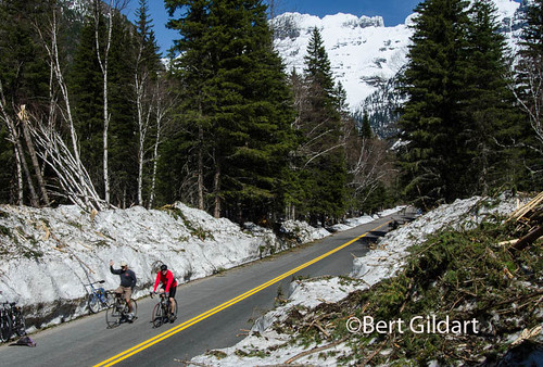
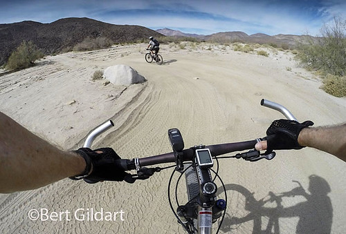
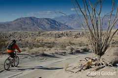
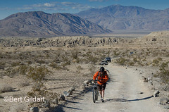
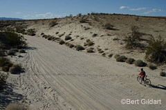
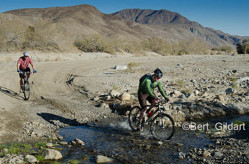
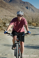
©Bert Gildart:  Yesterday, Photographer Ron Niebrugge and I biked about six miles from the Indian Hill Trailhead to a point known as the Goat Canyon Trestle.  We followed a railroad work path that paralleled a set of historic tracks and railroad line. Our route took us through dark tunnels, over lofty trestles and along a path that was sometimes strewn with rocks and railroad ties that we had to  “leap.”

Our destination, Goat Canyon Trestle, was built in 1932 after an earthquake collapsed one of the tunnels of the Carrizo Gorge section of the San Diego and Arizona Railway. At 200 feet tall and 750 feet long, Goat Canyon Trestle remains the longest, tallest curved wooden trestle ever built in the United States.  Impressive as it may be, the route came to be known as the “Impossible Railroad.”


Carrizo Gorge

Longest, tallest curved wooden trestle ever built in the United States. But it is remote!


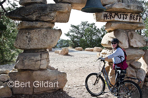
For years the trestle has been a popular destination for both hikers and bikers.  It is popular because movie scenes have been filmed here, meaning Carrizo Gorge has to be spectacular.  Nevertheless, the railroad company has at times imposed travel restrictions, though I’ve had difficulty determining what those might be today.

Prior to our departure I found that in 2008 Railroad Police had posted an internet “trespass notice.” But in the interim the route has been much traveled, so it wasn’t until we reached Goat Canyon that I finally saw a “No Trespass” sign, and it was riddled with bullet holes.

WHY BIKE?

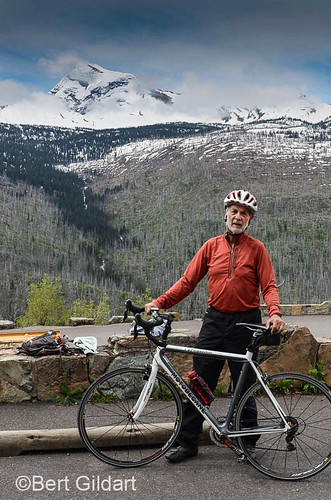
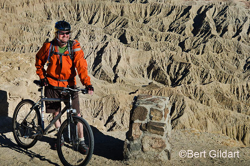
People such as Ron and I bike to such areas for the scenic rewards and for the area’s interesting history.  If indeed the area is closed, it should be opened as it provides access to some of the desert’s most beautiful scenery.


Carrizo Gorge Railroad No Tresspass Sign Wrecked Freight Train Cars Carrizo Gorge Tunnel Carrizo Gorge Trestle


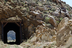
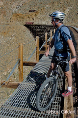
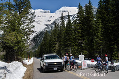
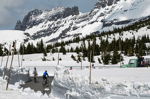
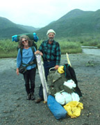
L TO R:  Sign near one of trestles in Carrizo Gorge (Hard to read isn’t it??);  final resting spot for freight cars that “jumped” tracks; biker passing through tunnel; bike rider crossing grating of trestle.


That said, we also concluded the Railroad had reasons they might want to exempt themselves from mishap.

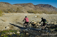
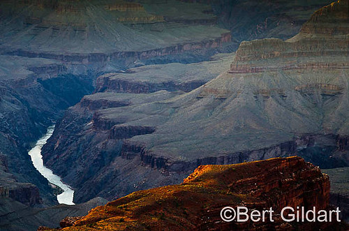
To access the trestle you must pass through magnificent Carrizo Gorge, but in places steep terrain abuts the path, meaning the slightest mis-turn of your handle bars could propel you on a most unpleasant journey.  In such places, I dismounted and found a secure detour by walking the railroad tracks.

TUNNELS AND TRESTLES

As we rode we passed through four tunnels and an equal number of trestles.  Obviously the trestles provided a route for trains but they also provided a route for us.  And here’s another place bikers need to pay attention.  Wire grating flanks the railroad tracks and though the grating measures four feet and is certainly wide enough to accommodate a bike the narrow passage was unnerving to me.

Though Ron pumped ahead, I dismounted several times when the wind blew.  However, on the way back I’d acquired my sea legs and learned to rivet my attention on the grating — and not on the deep gorges over which the grating passed – and on which we rode.

FREIGHT CAR JUMPS TRACK

About midway on our ride we came to a spot where two huge freight cars had “jumped” the tracks, then slid down the embankment.  Obviously the mishap resulted in huge financial losses for a company whose business must be marginal.

In the early years of the train’s history, lines moved passengers by day and freight by night, but as years passed, improved transportation, wars and maintenance problems brought an end to the train’s operations.  More recently these rails have been used for transporting sand and lumber and for the transporting of other goods between the U.S. and Mexico.  But time seems to have taken its toll and we found places where gratings were  held together with rope, and where boards have weathered away.  Little wonder the Impossible Railway seems to be discouraging use.  Trespass signs are a way of exempting themselves from legal entanglements.


Biker riding over Goat Trestle

Biker riding over Goat Trestle


Today, it appeared to Ron and me that much of the infrastructure should be repaired, so predicting the future seems difficult.  But, in Montana and in Idaho, I’m familiar with the wonderful mountain bike routes railroads have created from former lines.  Ancillary businesses have evolved making it a win-win proposition for almost everyone.  In the meantime, hiking guides offer challenging routes to Goat Trestle.

Whatever the future may hold for these rails Ron and I both concluded that our ride along the route of the Impossible Railroad will always rank as one of the best mountain bike trips – ever!


NOTE: In my next blog I’ll post a few more images from the “Impossible Railroad.”


——————

THIS TIME THREE YEARS AGO:

*Tour By Anza Borrego’s Retired Superintendent Mark Jorgensen


————-

4th ed. Autographed by the Authors

Hiking Shenandoah National Park

Hiking Shenandoah National Park is the 4th edition of a favorite guide book, created by Bert & Janie, a professional husband-wife journalism team. Lots of updates including more waterfall trails, updated descriptions of confusing trail junctions, and new color photographs. New text describes more of the park’s compelling natural history. Often the descriptions are personal as the Gildarts have hiked virtually every single park trail, sometimes repeatedly.

$18.95 + Autographed Copy


Big Sky Country is beautiful

Montana Icons: 50 Classic Symbols of the Treasure State

Montana Icons is a book for lovers of the western vista. Features photographs of fifty famous landmarks from what many call the “Last Best Place.” The book will make you feel homesick for Montana even if you already live here. Bert Gildart’s varied careers in Montana (Bus driver on an Indian reservation, a teacher, backcountry ranger, as well as a newspaper reporter, and photographer) have given him a special view of Montana, which he shares in this book. Share the view; click here.

$16.95 + Autographed Copy


What makes Glacier, Glacier?

Glacier Icons: 50 Classic Views of the Crown of the Continent

Glacier Icons: What makes Glacier Park so special? In this book you can discover the story behind fifty of this park’s most amazing features. With this entertaining collection of photos, anecdotes and little known facts, Bert Gildart will be your backcountry guide. A former Glacier backcountry ranger turned writer/photographer, his hundreds of stories and images have appeared in literally dozens of periodicals including Time/Life, Smithsonian, and Field & Stream. Take a look at Glacier Icons

$16.95 + Autographed Copy


Read Comments | 3 Comments »

Organ Pipe’s Ajo Mountain Loop – Recalling the Sounds of Silence

posted: February 19th, 2013 | by:Bert

©Bert Gildart:  Two days ago I rode my bicycle along Organ Pipe’s National Monuments Ajo Mountain loop road.  It is a 21-mile long gravel road, and though vehicular traffic is permitted, at this time of year it is sparse.  During my entire ride I saw less than a dozen cars.

Ajo Mountain-1

Ajo Mountain


But the point is that the silence was intense, and there are few other places Janie and I have visited where we could stop and say, “Listen!  What do you hear?”  The answer was nothing.  Absolutely nothing; and that is an observation we’ve been able to make in but few other settings.

Glacier National Park is one, and so is the Arctic National Wildlife Refuge.  But there was yet more about this isolated area of the park that thrilled me:  It is the heart of the Sonoran Desert, and though Janie has seen it before, we decided yesterday that we’d travel it again, but this time with lots of camera gear.  As a result, I am now able to post these images, and with them some thoughts about why I took them.


OrganPipe-5 OrganPipe-8 OrganPipe-12


L TO R:  All images show organ pipe, but the last two in this row show a bizarre structure biologists call a “cristates.”


Appropriately, the first picture summarizes the drive.  It is, after all, the Ajo Mountain Drive so the top image portrays Ajo Mountain.  Just beyond the mountain is the Tohono O’odham Indian Reservation, and once members of the tribe made a living from the lands setting up ramadas near water sources, such as seen in another image.  The park interprets their tenure in the park with the construction of a ramada set up on a bank overlooking Diablo Wash.  Nearby, lands are ideal for the growth of both the saguaro and the organ pipe, both of which the O’odham harvested.  Using the woody ribs of dead saguaros to create a tool they called a kupit, the tribe plucked fruit from the spiny columns and arms of the Sonoran’s two most conspicuous species those being, of course, the organ pipe and the saguaro.

Though the two trees share a similar environment, they begin life differently.  Saguaro begins in the shade of a palo verde — or in the shade of one of the other “bean plants” that grows here, such as the mesquite.  But not so the organ pipe, which requires more heat, and sometimes that comes from an association with volcanic rock.

Also of interest is the fact the organ pipe (and the saguaro) sometimes produces a bizarre formation called a crest, and on the day of my bike ride a group of Canadians pointed out the structure to me.  In turn, I wanted Janie to see it, and I needed her to hold one of the strobe lights necessary to eliminate harsh shadows.  I wanted her “to hear” the silence.


OrganPipe-6 OrganPipe-18 OrganPipe-15


L to R:  Ramada overlooking Diablo Wash; new (the yellow) arms emerging from organ pipe; close up of cristates.


Cristates is another name used to describe the unusual growth patterns and though the shape is common, scientists are at a loss to explain their existence.  Some, according to a park brochure, say the growth results from genetics.  Others believe it could be frost while yet others say the pattern results from imbalance in growth hormones.  Though there is much to be said for understanding, there’s also much to be said for aesthetics, and the organ pipe with all of its shapes and peculiarities satisfies the complex issue of simple beauty.

My last images show the beginning of new arms on an organ pipe.  Again, these structures add to the paragon of the Sonoran, and that status along with the silence Janie and I experienced on this my second tour has elevated Organ Pipe to a place of simple quiet beauty that should not be missed.


———————————-

THIS TIME SIX  YEARS AGO:

*Airstream Camper Tips from Organ Pipe


————–

BOOKS FOR SALE:


4th ed. Autographed by the Authors

Hiking Shenandoah National Park

Hiking Shenandoah National Park is the 4th edition of a favorite guide book, created by Bert & Janie, a professional husband-wife journalism team. Lots of updates including more waterfall trails, updated descriptions of confusing trail junctions, and new color photographs. New text describes more of the park’s compelling natural history. Often the descriptions are personal as the Gildarts have hiked virtually every single park trail, sometimes repeatedly.

$18.95 + Autographed Copy


Big Sky Country is beautiful

Montana Icons: 50 Classic Symbols of the Treasure State

Montana Icons is a book for lovers of the western vista. Features photographs of fifty famous landmarks from what many call the “Last Best Place.” The book will make you feel homesick for Montana even if you already live here. Bert Gildart’s varied careers in Montana (Bus driver on an Indian reservation, a teacher, backcountry ranger, as well as a newspaper reporter, and photographer) have given him a special view of Montana, which he shares in this book. Share the view; click here.

$16.95 + Autographed Copy


What makes Glacier, Glacier?

Glacier Icons: 50 Classic Views of the Crown of the Continent

Glacier Icons: What makes Glacier Park so special? In this book you can discover the story behind fifty of this park’s most amazing features. With this entertaining collection of photos, anecdotes and little known facts, Bert Gildart will be your backcountry guide. A former Glacier backcountry ranger turned writer/photographer, his hundreds of stories and images have appeared in literally dozens of periodicals including Time/Life, Smithsonian, and Field & Stream. Take a look at Glacier Icons

$16.95 + Autographed Copy


Read Comments | Comments Off

Biking to Font’s Point, How to Overpower A Sandy Challenge

posted: January 18th, 2013 | by:Bert

©Bert Gildart:  Here are some images from a bike trip Adam Maffei and I made to Font’s Point several days ago.  The destination in Anza Borrego Desert State Park  provides incredible views, but the struggle of biking there was a challenge, one which we could have simplified if only we’d been familiar with the techniques for peddling through deep desert sand.

Adam and I drove to Peg Leg, parked the truck, unloaded our bikes and then peddled three miles along the highway linking to a dirt road that then twists over sand and gravel for four miles to the famous overlook.  We were flanked by  desert cacti such as ocotillo, catclaw, and cholla.


FontsPoint (3 of 4)

View From Font's Point


We rode mountain bikes and at 70 psi our tires were properly inflated for road travel, but not for sand travel.  What we should have done was to reduce the psi to about 25 pounds, thereby increasing surface area. When you return to the pavement you can re-inflate your tires using a CO2 cartridge or — with prolonged effort — a small hand pump.  And because you will be riding through an area flanked by cactus thorns, which are sometimes difficult to avoid, you should change out your normal tubes for “slime” tubes.

SandyBike (1 of 1)

Box (shown at top) showing "slime tube," tire removal prongs, two tire pumps and four CO2 cartridges.


Down here (remember, we’re from Montana), everyone knows what they are, but simply said, the tubes contain a slim that immediately fills in the type of puncture created by a desert thorn.

Despite a certain amount of naivety, we made it through, but there were several deep sandy spots over which we had to walk our bikes, for tires ground deep into the sand.  But the payoff was extraordinary.

SOMETHING FOR EVERYONE

Not only is the view from Font’s point mind boggling, but it is also historic and is important from the paleontological perspective.  In 1775 Pedro Font was the chaplain and navigator on Spain’s second expedition from Tubac, Mexico to Mission San Gabriel in California. The expedition was led by Spanish explorer Juan Bautista de Anza, for whom this park was named.


FontsPoint (4 of 4) FontsPoint (10 of 1) FontsPoint (1 of 4)

Anza Borrego contains so many wonderful sand roads that it behooves bikers to learn the few techniques necessary for facilitating desert riding.  Often you have the roads to yourself, but sometimes, as shown by looking closely in the middle image, you’ll see that you must contend with occasional vehicular traffic.  No big deal, MOST drivers slow down, wave,  smile, and go on by.  But there’s always one…  so sorry gentle reader but there may come when it is absolutely incumbent on  oneself  to express pent up inner feeling by “flinging out  a wave.”  


As well these incredible badlands harbor the remains of many prehistoric animals to include the ground sloth, short-faced bear, dire wolf, sabertooth cat, mastodon, mammoth, giant zebra, half-ass, camel, yesterday’s camel, llama, giant camel, pronghorn, elk, deer, shrub oxen, and the Bautista horse.

In other words, a trip to Font’s Point may well offer a little something for everyone. Next time, however, we’ll take along a tire pump, deflate the tires and then inflate them back to road pressures when we return to the road (Road bikes).

I’ve also change my regular tires out for slime tube tires, doing so right away because I had a flat.  I was lucky because the flat was created by a slow leak. The culprit was a tiny ocotillo thorn and I didn’t notice the flat until next day.  I was lucky, but I won’t be trusting to luck again.  I’m now prepared.


xxxxxxxxx


(NOTE: My posting several years ago on Night of the Grizzly continues to generate comments.  The Public TV documentary about Glacier’s first fatal maulings has recently gone national.)


——–

THIS TIME LAST YEAR:

*Mysterious Rock Art


—–


BOOKS FOR SALE:


4th ed. Autographed by the Authors

Hiking Shenandoah National Park

Hiking Shenandoah National Park is the 4th edition of a favorite guide book, created by Bert & Janie, a professional husband-wife journalism team. Lots of updates including more waterfall trails, updated descriptions of confusing trail junctions, and new color photographs. New text describes more of the park’s compelling natural history. Sometimes the descriptions are personal as the Gildarts have hiked virtually every single park trail, sometimes repeatedly.

$18.95 + Autographed Copy


Big Sky Country is beautiful

Montana Icons: 50 Classic Symbols of the Treasure State

Montana Icons is a book for lovers of the western vista. Features photographs of fifty famous landmarks from what many call the “Last Best Place.” The book will make you feel homesick for Montana even if you already live here. Bert Gildart’s varied careers in Montana (Bus driver on an Indian reservation, a teacher, backcountry ranger, as well as a newspaper reporter, and photographer) have given him a special view of Montana, which he shares in this book. Share the view; click here.

$16.95 + Autographed Copy


What makes Glacier, Glacier?

Glacier Icons: 50 Classic Views of the Crown of the Continent

Glacier Icons: What makes Glacier Park so special? In this book you can discover the story behind fifty of this park’s most amazing features. With this entertaining collection of photos, anecdotes and little known facts, Bert Gildart will be your backcountry guide. A former Glacier backcountry ranger turned writer/photographer, his hundreds of stories and images have appeared in literally dozens of periodicals including Time/Life, Smithsonian, and Field & Stream. Take a look at Glacier Icons

$16.95 + Autographed Copy


Read Comments | 1 Comment »

Biking Through Desert History

posted: January 14th, 2013 | by:Bert

©Bert Gildart: On December 20, 1775, Juan Bautista de Anza led 240 Sonoran colonists through the same valley that Don Dennis, Adam Maffei and I toured several days ago by mountain bike. Because the valley remains under the control of California’s Anza Borrego State Park, little about the area has changed.

Although you can drive a high clearance vehicle along the rutted road, the valley can best be accessed by biking.  Thick sand, of course, presents its challenges and at times we had to dismount to walk our bikes.  But the rewards (Biking Fanatic) were substantial, for our explorations provided great insights into the struggles de Anza confronted.


Coyote1

Back dropped by Coyote Mountain, we cycled through streams


The valley is cut by Coyote Creek and flanked to the east by the Coyote Mountains and to the west by the San Ysidro Mountains. Last year Don and I (after two tries, one, two) climbed Coyote Mountain, so the prominent peak grabbed our attention and made for much reminiscing.

But it was the valley floor that sustained our attention.  We came to a trailhead sign pointing to Alcoholic Pass, named according to a guide book for the switchback-ish nature of the trail.

Next, we came to an area our map referred to as the Desert Gardens. We spent a few minutes hiking around–taking photographs–not only because of the garden’s beauty but because it had once been the home to a group of Native Americans known as Cahuilla.

CANYON CALLED HOME


“A Canyon Called Home,” began an interpretive panel. “People,” the sign continued, “raised families in Coyote Canyon… With sheltered canyons and year around running streams, Coyote Canyon was the perfect place to call home.”


Coyote2 Coyote4 Coyote3


From the gardens we rode another mile, stopping shortly after crossing a stream near another interpretive panel. This one further described the hardships of de Anza’s expedition, explaining that Gertrudis Rivas Linares gave birth to a son, Salvador, on Christmas day. “Next day she mounted a horse for the journey north.”

Don, Adam and I cycled yet about another mile, eventually reaching a point at which the road became quite rocky.  Here, we turned around and retraced our route, taking about another hour to return to our camp.  Our odometers said we had ridden about 12 miles and over half of those miles were through sand.  We concluded that our day of biking with history had been challenging, but that it had also been extremely satisfying.

We vowed that someday soon we’d repeat our ride.


————————————————————————————————————-

THIS TIME LAST YEAR

*Year of the Dragon


————————————————————————————————————-


4th ed. Autographed by the Authors

Hiking Shenandoah National Park

Hiking Shenandoah National Park is the 4th edition of a favorite guide book, created by Bert & Janie, a professional husband-wife journalism team. Lots of updates including more waterfall trails, updated descriptions of confusing trail junctions, and new color photographs. New text describes more of the park’s compelling natural history. Sometimes the descriptions are personal as the Gildarts have hiked virtually every single park trail, sometimes repeatedly.

$18.95 + Autographed Copy


Big Sky Country is beautiful

Montana Icons: 50 Classic Symbols of the Treasure State

Montana Icons is a book for lovers of the western vista. Features photographs of fifty famous landmarks from what many call the “Last Best Place.” The book will make you feel homesick for Montana even if you already live here. Bert Gildart’s varied careers in Montana (Bus driver on an Indian reservation, a teacher, backcountry ranger, as well as a newspaper reporter, and photographer) have given him a special view of Montana, which he shares in this book. Share the view; click here.

$16.95 + Autographed Copy


What makes Glacier, Glacier?

Glacier Icons: 50 Classic Views of the Crown of the Continent

Glacier Icons: What makes Glacier Park so special? In this book you can discover the story behind fifty of this park’s most amazing features. With this entertaining collection of photos, anecdotes and little known facts, Bert Gildart will be your backcountry guide. A former Glacier backcountry ranger turned writer/photographer, his hundreds of stories and images have appeared in literally dozens of periodicals including Time/Life, Smithsonian, and Field & Stream. Take a look at Glacier Icons

$16.95 + Autographed Copy


Read Comments | Comments Off

Return to Hermit’s Rest

posted: October 5th, 2012 | by:Bert

©Bert Gildart:  Yesterday Janie and I bicycled to what has become my most favorite part of Grand Canyon: Hermit’s Rest.  Because Janie had not biked much recently we decided to try out the shuttle system, which we found surprisingly easy to use and the bus drivers more than helpful.


Tarantula (31 of 1)

Janie at "entrance" to Hermit's Rest


Because it was our first time loading bikes onto the bus, the driver showed us which levers to pull – and push – and within a matter of minutes we had our two bikes loaded onto the rack, which is outside and located on the very front of the bus.  About ten minutes later we unloaded our bikes near Hopi Point.  In that way we eliminated the most uphill portion of the Hermit’s Road Drive, which is open only to shuttle buses and to bikes.

HARVESTING PINYON PINE NUTS

Essentially, we were riding in a Pinyon/Juniper forest to the South all flanked to the north by the depths of the Grand Canyon.  As we rode we could see that the pinyon pine nuts were ripe, and we had learned from our week now of exploring this park that many Native families were gathering nuts, perfectly legal for all ethnic groups.  Several days early Janie had visited with an elderly Native lady who said this was the very best crop they’ve had in several years. “Next year,” she said, “there probably won’t be many nuts.”


Tarantula) PinyonPineNuts (1 of 2)


L to R: (Click to enjoy as larger images)  Tarantula along Hermit’s Rest, pinyon pine showing seeds inside cone and ready to burst free.


Nuts are best gathered on the ground as when in the cones on the trees they are exceedingly sticky.  Natives gather them in huge quantities, then bake the nuts and when properly prepared “taste better than peanut butter.”  We noticed the ground, beneath stands of pinyon pine trees, was thick with cones and that the cones extruded seeds.  We continued our ride, reaching Hermit’s Rest about an hour later.

Today, Hermit’s Rest is a small stone building that serves as a place for visitors to rest and stroll along the canyon rim.  It’s also the point at which the road runs out and where buses and bikers must turn around.

ANOTHER TARANTULA

Several days ago while biking the area just west of The Rest, I found a tarantula, and in almost the same place Janie and I spotted yet another.  This one seemed larger, and by now I had learned a bit more about handling this huge arachnid – and hopefully (for your viewing pleasure) the making of better tarantula images.  (See previous post for comparison.)


HermitsRest (33 of 1)

Colorado River, which has been at work for over a million years.


We completed our ride – almost 18 miles – just as the sun neared the horizon.  It lite the canyon in dramatic ways – even after it had disappeared.  Below us we could see the famous Colorado River that had been at work for well over a million years.  It was a humbling experience and we rode on, returning to our Airstream near dark.  We were tired but invigorated.


—————————————-


AIRSTREAM TRAVELS TWO YEARS AGO:

*Shenandoah and the Monarch Butterfly


ADS FROM AMAZON AND GOOGLE AUGMENT OUR TRAVELS:


Read Comments | 1 Comment »