Glacier As it Once Was — Experienced by Biking
posted: June 16th, 2018 | by:Bert
GLACIER AS IT ONCE WAS: Each year while snow plows work to clear the Going-to-the-Sun Road the segment between Avalanche Creek and Logan Pass is open to bikers only.
What that means is that bike riders get a chance to see one of the most beautiful places in the world without having to cope with the hordes of visitors Glacier National Park will soon experience. That means if you are a rider, you can stop anywhere you want and that you won’t be surrounded by barking dogs, children and adults screaming, or motorcyclists reeving their unmuffled Harley Davidsons.
What you’ve got NOW approaches a spiritual experience, and I can testify that since arriving in Glacier in 1960 you’ve got Bird Woman Falls still cascading down Mount Cannon after all these years. Then there’s Heaven’s Peak, and dozens of other glacier-influenced peaks.

This 78-year old man worked and worked
to properly condition himself for the challenging ascent to Logan Pass, elevation 6646. Who could it be?
To enjoy these settings, of course you must be in shape, for the 32-mile round trip ride is 3,259 feet up. Put in other words, that’s 16 miles up and 16 miles down. In short, the ride is a challenge and throughout the year I work hard to maintain the fitness required to make the trip. I believe that anyone who really wants to enjoy nature in this manner can work hard and do the same. I made this ride June 12, 2018.
There are, of course, different ways to make the ride. Some tuck in their chins, look straight ahead make the climb in 59 minutes. That speed data is provided by my Garmin, which also tells me when my heart rate exceeds 150, the level my doctor tells me I should not exceed for more than a few minutes. I adhere to his advice, stopping to rest when I’m over the limit.
For comparative purposes, I’m slow and this year I took 3 hours and 59 minutes, but for me that was just perfect. Also, my objectives were different. When I ride I want to look around, enjoy the bighorn sheep I saw grazing near Weeping Wall; marvel at the two black bears that scampered up a tree on my approach; and visit with a few other riders who share my passion of seeing the park before Flathead Valley was discovered – and destroyed. After the road opens for vehicular traffic, believe me, you won’t be able to find a parking place at Logan Pass after 9 a.m. Soon it will literally be bumper to bumper traffic.


Many try to make the ride from Avalanche Creek Campground, forgetting
that you must be properly conditioned. Success then is certainly a time
for a jubilee. Just look at the scenery, to include Bird Woman Falls as depicted in center photo.
For me, visiting with the younger crowd also offered a very ego boosting component. In a joking way I told them I was ashamed they were passing me, as I probably had 55 more years of experience than they did. Knowing then that I was on the dark side of my 70’s, the group of four greeted me at Logan Pass with cheers. They pointed their thumbs up and then pumped the thin alpine air that you find at this 6646 foot-high pass, also a part of the Continental Divide.
Though it took almost four hours to make the 16-mile climb, I was back at my truck in little more than an hour — coasting much of the way at speeds up to 25 mph. Turning on my Sirius, I changed the station from Blue Grass to Opera. The station was playing The Blue Danube Waltz, and for a while vivid memories of the way Glacier used to be danced before me. I was thankful that I was able to relive those moments if only for about six hours.
——————————————
THIS TIME LAST YEAR: In Glacier Bikes Should Prevail
(See this post from last year for map of the ride I made this this year.)
4th ed. Autographed by the Authors
Hiking Shenandoah National Park
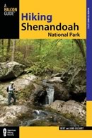 Hiking Shenandoah National Park is the 4th edition of a favorite guide book, created by Bert & Janie, a professional husband-wife journalism team. Lots of updates including more waterfall trails, updated descriptions of confusing trail junctions, and new color photographs. New text describes more of the park’s compelling natural history. Often the descriptions are personal as the Gildarts have hiked virtually every single park trail, sometimes repeatedly.
Big Sky Country is beautiful
Montana Icons: 50 Classic Symbols of the Treasure State
![]() Montana Icons is a book for lovers of the western vista. Features photographs of fifty famous landmarks from what many call the “Last Best Place.” The book will make you feel homesick for Montana even if you already live here. Bert Gildart’s varied careers in Montana (Bus driver on an Indian reservation, a teacher, backcountry ranger, as well as a newspaper reporter, and photographer) have given him a special view of Montana, which he shares in this book. Share the view; click here.
Montana Icons is a book for lovers of the western vista. Features photographs of fifty famous landmarks from what many call the “Last Best Place.” The book will make you feel homesick for Montana even if you already live here. Bert Gildart’s varied careers in Montana (Bus driver on an Indian reservation, a teacher, backcountry ranger, as well as a newspaper reporter, and photographer) have given him a special view of Montana, which he shares in this book. Share the view; click here.
$16.95 + Autographed Copy
What makes Glacier, Glacier?
Glacier Icons: 50 Classic Views of the Crown of the Continent
![]() Glacier Icons: What makes Glacier Park so special? In this book you can discover the story behind fifty of this park’s most amazing features. With this entertaining collection of photos, anecdotes and little known facts, Bert Gildart will be your backcountry guide. A former Glacier backcountry ranger turned writer/photographer, his hundreds of stories and images have appeared in literally dozens of periodicals including Time/Life, Smithsonian, and Field & Stream. Take a look at Glacier Icons
Glacier Icons: What makes Glacier Park so special? In this book you can discover the story behind fifty of this park’s most amazing features. With this entertaining collection of photos, anecdotes and little known facts, Bert Gildart will be your backcountry guide. A former Glacier backcountry ranger turned writer/photographer, his hundreds of stories and images have appeared in literally dozens of periodicals including Time/Life, Smithsonian, and Field & Stream. Take a look at Glacier Icons
$16.95 + Autographed Copy
Read Comments | Comments Off


")
")
")
")


")


")

")


