Thoughts And Images that Followed From the Solar Eclipse
posted: September 13th, 2017 | by:Bert
©Bert Gildart: Last year Janie and I learned from Adam and Susan Maffei, our good friends from Vermont, that on August 21, 2017, the moon will move across the sun to completely eclipse the sun during the course of its 3-1/2 hour journey.
“Make reservations now,” they had encouraged, “and if you do we’ll meet you in Glenrock, Wyoming. But we’ve got to make plans now. Hotel and campgrounds are already beginning to fill!”

Progression of solar eclipse which lasted for about three hours.
They weren’t exaggerating, and the word was spreading fast. Six months later, hotels were charging $1000 a night. But we got by cheap. For a mere $55 we purchased the right to park our Airstream on a tiny spot of grass at the Platte River Campground in Glenrock, Wyoming. And all this simply because it was predicted that the moon was going to blot out the sun for several minutes, and that we would be in the perfect path to experience this happening.
Though our small grass site was reserved, nevertheless, we arrived several days before the big event, and of course, we were not alone. An hour after we arrived, a couple pulled into a site immediately adjacent to us. He introduced himself as “Chip,” but as the day progressed we learned that “Chip” had a doctor’s degree and that he had been part of the team that placed the Rover on planet Mars!
Like us “Chip” (also known as Philip Good) had also made reservations months ago and he, too, was rendezvousing with a friend, Frank Nadell. Though Frank worked as a fireman he was so knowledgeable about astronomy that we concluded Nadell qualified for an honorary doctor’s degree. From them we learned about sun spots, Bailey’s beads, the ring, and the fiery red circle that should inscribe the sun to become the corona. And so, with newly acquired knowledge we gathered together with the masses of “eclipse chasers” anxious for the event to begin.


Images of eclipse immediately before totality and shortly after.
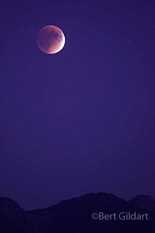
Finally the morning arrived and the crowd grew silent and remained so until 10:22 at which time the moon began its journey over the sun, taking a bite in the upper right arc of the sun. Then, the bite grew bigger and then yet bigger.
The improbability of this happening stirred a primordial reaction from the crowd and in sync, everyone began howling like packs of wolves. But then the crowd grew silent again, content to watch and whisper. How could two spheres separated by 100 million miles find an alignment that affects Earth’s inhabitants?


Over 1,500 “eclipse chasers” set up camp in Glenrock, Wyoming, for one of the most dramatic solar events of the century.
Attendees included our friend Adam (broad brim hat) visiting with astronomy enthusiast Frank Nadell;
Janie, back dropped by my 800mm lens; and Philip “Chip” Good
who had been a member of the team responsible for placing the Rover on Mars.
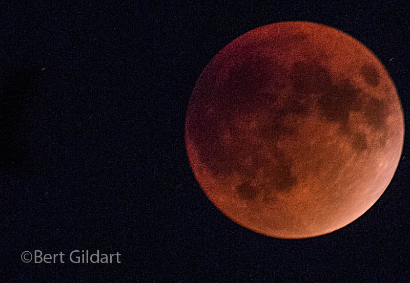
At 11:42 the moon moved to cover the entire face of the sun, turning day into night and did so for almost four minutes. As anticipated birds settled into trees, planets and stars appeared, and temperatures dropped to the point where people dug out their coats and sweaters. To restate the obvious, we were experiencing a total eclipse of the sun. But the world didn’t end as some doomsayers had predicted.


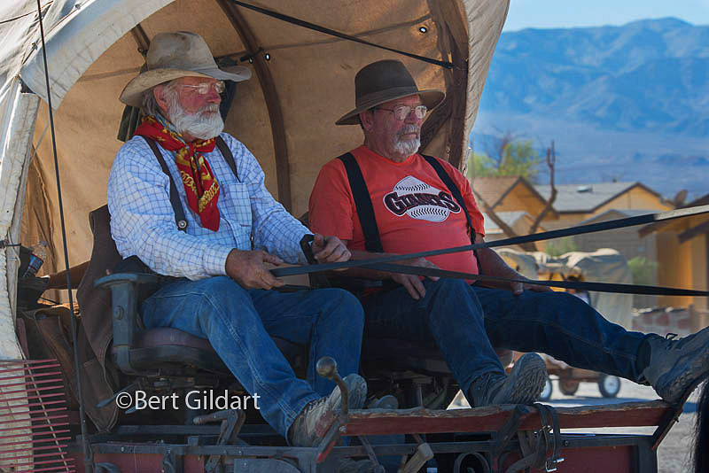
Frank Nadell and Philip Good demonstrate proper technique for viewing the eclipse;
Frank waving in front of our Airstream; Frank and telescopes.
At 1:09 the moon completed it journey across the face of the sun, which then brighten our world just as it always does, but the event had an impact that I’m still attending to. Randomness, it seems, punctuates both our world and our universe – and that can be either good or bad, of which I’m not yet sure. But I do know this was a providential event and that Janie and I were fortunate to see it on a day when the skies were clear, winds had diminished, and that our fellow attendees were gregarious. And all these happenings occurred at a time when so many unanswered questions remain concerning mankind’s future in the universe.
————
Eleven Years Ago At This Time:
Kayaking to the Wreck of the Francisco Morazon
4th ed. Autographed by the Authors
Hiking Shenandoah National Park
 Hiking Shenandoah National Park is the 4th edition of a favorite guide book, created by Bert & Janie, a professional husband-wife journalism team. Lots of updates including more waterfall trails, updated descriptions of confusing trail junctions, and new color photographs. New text describes more of the park’s compelling natural history. Often the descriptions are personal as the Gildarts have hiked virtually every single park trail, sometimes repeatedly.
Big Sky Country is beautiful
Montana Icons: 50 Classic Symbols of the Treasure State
![]() Montana Icons is a book for lovers of the western vista. Features photographs of fifty famous landmarks from what many call the “Last Best Place.” The book will make you feel homesick for Montana even if you already live here. Bert Gildart’s varied careers in Montana (Bus driver on an Indian reservation, a teacher, backcountry ranger, as well as a newspaper reporter, and photographer) have given him a special view of Montana, which he shares in this book. Share the view; click here.
Montana Icons is a book for lovers of the western vista. Features photographs of fifty famous landmarks from what many call the “Last Best Place.” The book will make you feel homesick for Montana even if you already live here. Bert Gildart’s varied careers in Montana (Bus driver on an Indian reservation, a teacher, backcountry ranger, as well as a newspaper reporter, and photographer) have given him a special view of Montana, which he shares in this book. Share the view; click here.
$16.95 + Autographed Copy
What makes Glacier, Glacier?
Glacier Icons: 50 Classic Views of the Crown of the Continent
![]() Glacier Icons: What makes Glacier Park so special? In this book you can discover the story behind fifty of this park’s most amazing features. With this entertaining collection of photos, anecdotes and little known facts, Bert Gildart will be your backcountry guide. A former Glacier backcountry ranger turned writer/photographer, his hundreds of stories and images have appeared in literally dozens of periodicals including Time/Life, Smithsonian, and Field & Stream. Take a look at Glacier Icons
Glacier Icons: What makes Glacier Park so special? In this book you can discover the story behind fifty of this park’s most amazing features. With this entertaining collection of photos, anecdotes and little known facts, Bert Gildart will be your backcountry guide. A former Glacier backcountry ranger turned writer/photographer, his hundreds of stories and images have appeared in literally dozens of periodicals including Time/Life, Smithsonian, and Field & Stream. Take a look at Glacier Icons
$16.95 + Autographed Copy
Read Comments | Comments Off


")
")
")
")


")
")
")
")
")
")
")
")
")
")


")
")
")
