EXPLORE — Enjoying America’s National Parks from your RV
posted: November 13th, 2018 | by:Bert


FRONT COVER/BACK COVER
RICH’S WORK in national parks is also in depth, and if you have followed his blog you know that his family has visited lots of national parks over the years. Visiting the parks has been an obsession that started even before he had an Airstream, and over 20 years later the family is still actively seeking out more every time we get in the Airstream. (Flaming Gorge Nat’l Rec Area, in recent posts, is an example.)
Rich and I have talked about writing a book together, but it was only a couple of years ago that we got serious about the idea, and settled on a format. Rich refers to my contributions as a “warm & fuzzy style of travel essays about a few selected national parks. He says his style is more of a “here’s how you do it.” We both agreed that because we are very different writers the final presentation would provide a better understanding of our national parks than could be provided by any single writer.
The book is called EXPLORE: Enjoying America’s National Parks From Your RV. We used the term “RV” instead of Airstream because the book can be useful to any RV traveler, but as Rich wrote, “just between you and me, you’ll find photos of Airstreams almost exclusively on the pages.”
This is book Rich and I have wanted to write for many years. We have both given slide shows about visiting America’s National Parks at rallies, and have found that each time the room was packed. Though the book is currently in layout it should be available by January 1. In published form it will run about 170 pages and measure 10-3/4 by 10-3/4. It will include approximately 150 high quality, story-telling images.
————–
SOME MORE SAMPLES FROM OUR LATEST BOOK (From Rich’s Blog)
Discover the romance, fun and adventure of exploring the U.S. National Parks from the comfort of your Airstream.
Bert Gildart and Rich Luhr bring you their decades of RV travel experience in this spectacular collection of photos and first hand accounts. Their stories and images will inspire and prepare you to begin visiting the 400+ National Parks yourself.
Each chapter of the book alternates between Rich’s practical how-to tips and suggestions for planning a national park visit, and each chapter of the book alternates between Bert’s inspiring first-person accounts of some of his most memorable adventures. Lavishly illustrated with photos from national parks, this book is both a beautiful coffee-table book and a useful guide.


The book is scheduled for release in January 2019, but you can reserve a copy now at a discounted price. Normally $24.95, your advance purchase will be just $18.00 including shipping in the US & Canada. It will be shipped automatically when copies are in stock.
Reserve your copy at this discounted price by clicking here
184 pages, softcover, 10 3/4″ x 10 3/4″ Collectors book format
Bert Gildart has had a five-decade career as a nationally-recognized wildlife photographer and author whose stories have appeared in dozen of magazines to include Smithsonian, National Wildlife and Travel & Leisure. He has been a regular contributor to Airstream Life magazine since the magazine’s inception. Bert has also written fifteen books, seven of which were national park guide books coauthored with his wife Jane Gildart. The couple travel often in their Airstream and have visited hundreds of national parks.
Rich Luhr is Publisher of Airstream Life magazine, and author of The Newbies Guide to Airstreaming as well as The (Nearly) Complete Guide to Airstream Maintenance. With his family he has visited well over 140 national parks by Airstream.
Reserve your copy
——————–
A STORY ABOUT THE YEARS JANIE AND I HAVE SPENT TRAVELING IN OUR AIRSTREAM, OFTEN EXPLORING OUR NATIONAL PARKS. LOTS OF ADDITIONAL LINKS:
http://gildartphoto.com/weblog/2009/10/11/airstream-and-our-100000-miles-on-the-road
Read Comments | Comments Off


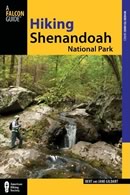 Hiking Shenandoah National Park is the 4th edition of a favorite guide book, created by Bert & Janie, a professional husband-wife journalism team. Lots of updates including more waterfall trails, updated descriptions of confusing trail junctions, and new color photographs. New text describes more of the park’s compelling natural history. Often the descriptions are personal as the Gildarts have hiked virtually every single park trail, sometimes repeatedly.


")
")

")

")
")
")
")

")
")


")
")


")


")

")


