Coyote Canyon and the Anza Expedition

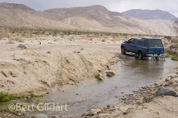
Crossing Coyote Creek
©Bert Gildart: On December 20, 1775, Juan Bautista de Anza led 240 Sonoran colonists through the same valley that Janie and I toured yesterday. Because the valley remains under the control of California’s Anza Borrego State Park, little about the area has changed.
The valley can only be accessed by driving along a sand road, and then only for a limited distance. For us, that distance was dictated by the rocks that began to crop up along the jeep road and the fact we did not want to take any chances of damaging the four-wheel drive truck we rely on to pull our Airstream . Though others continued on (we might return with mountain bikes), we stopped several miles short of the road’s terminus.
Still, our explorations provided great insights into the struggles Anza confronted. Eventually, he continued on with the colonists to found San Francisco, but the obstacles from 1775 remain today.
A CANYON CALLED HOME
The valley is cut by Coyote Creek and flanked to the east by the Coyote Mountains and to the west by the San Ysidro Mountains. But it was the valley floor that grabbed our attention.
First, we came to a trailhead sign pointing to Alcoholic Pass, named according to a guide book for the switchback-ish nature of the trail.
Next, we came to an area our map referred to as the Desert Gardens. We spent several hours hiking around–taking photographs–not only because of the garden’s beauty but because it had once been the home to a group of Native Americans known as Cahuilla.
“A Canyon Called Home,” began an interpretive panel. “People raised families in Coyote Canyon… With sheltered canyons and year around running streams, Coyote Canyon was the perfect place to call home.”

Appreciating cacti
Another nearby interpretive sign proclaimed that this canyon was home to a greater diversity of life than anywhere else in the park; adding that five separate areas here had been designated as “sensitive habitats” and that Anza-Borrego contained one quarter of all the lands in California designated as state wilderness. We understood that part of the sensitivity was out of concern for the Peninsular bighorn sheep, now endangered. Though we didn’t see sheep yesterday, we certainly saw sign.
PHOTO TECHNIQUES
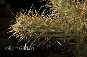
Cacti were dense and though we could easily side step them, we wondered about de Anza and his stock. We had the luxury, however, to appreciate the biology of the cholla and other plants with thorns, recalling that botanists say that thorns evolved from leaves–and served specific functions in this land of little rain. Janie and I photographed the cholla, using two strobe lights, firing them remotely using the built-in strobe on the Nikon D300. (Nikon refers to this capability as its “Advanced Wireless Lighting,” as no chords are required.)
As well I selected the manual exposure mode, exposing at f22 at 250 of a second, thinking that by overpowering ambient light and, so, creating a black background, I could dramatize the thorns.
PARTING PHOTO
From the gardens we drove another mile, stopping shortly after crossing a stream at another interpretive panel. This one further described the hardships of Anza’s expedition, explaining that Gertrudis Rivas Linares gave birth to a son, Salvador. “Next day she mounted a horse for the journey north.”

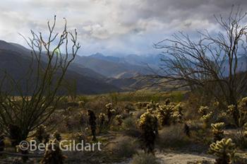
Plant profusion of the Desert Gardens
Here we turned around, reaching the Desert Gardens just as the sun began dipping into the San Ysidro Mountains. The sun backdropped the cholla, imparting a radiance not possible with other types of lighting.


January 26th, 2008 at 3:15 pm
Bert,
I just have to tell you what a fabulous article you had in the winter 2007 Airstream Life magazine. “Appalachian Moments” captured the essence of a place near and dear to my heart.
Congratulations on an excellent article.
Renee
January 10th, 2010 at 4:52 pm
[...] the other direction we could see the San Ysidro Mountains, and then, between us and the mountains, Coyote Creek, the creek along which Juan Bautista de Anza Valley rode in 1774. Indeed, this trail offers immense historical [...]