Mountain Biking in Anza Borrego Desert Park — A Challenge
©Bert Gildart: Several days ago a friend and I coerced our significant others to help with logistics for an incredible bicycle ride in Anza Borrego Desert State Park.
Loading bikes in the back of a pickup, we drove up Montezuma Grade, and that’s where we began our biking adventure, riding into Culp Valley over a sand- and rock-covered road. The day before it had snowed, and we were surrounded by peaks that sparkled white. Yes, this was all part of the Sonoran Desert, and we had been lured by the prospect of seeing great beauty and possibly Indian morteros. Once, the Kumeyaay Indians had lived here in concert with the land.
My companion was Gareth Pritchard, a man I met last year while biking the Ajo Mountain Loop Road in Organ Pipe National Monument. Gareth was from Wales, but immigrated to Canada where he worked in the business of hotel management. We have stayed in touch.
After a three tortuous-mile ascent Gareth and I prepare to descend.
Just turn the bike around.
But it was his volunteer work subsequent to retirement that seemed so rewarding. Gareth joined a group who assemble old bikes. Components are then shipped to Africa, and Gareth said that in some of the impoverished villages bikes elevate the standard of living for many residents. “Bikes,” he says, “are absent in some villages, and they provide mobility.”
We visited about those interests as we rode, but soon settled into the challenge of the ride, which began with a steep climb that continued for about three miles. The ride then plummeted toward Grapevine Canyon.
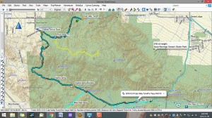
Gareth and I both enjoy recording our adventures with our respectively-owned Garmins, but Gareth’s Garmin went beyond mine, for he has learned how to create maps of his adventures, which he shared with me. “Look,” he said, “at the snake-like section in the map’s left center. That’s where the route really descends. Wet sand will add to the challenge and is where our fun really begins.”
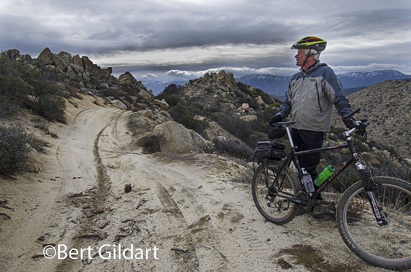
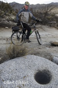
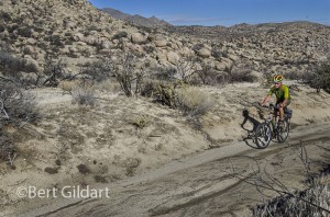
My image of Gareth back dropped by jeep tracks and rocks is where the hair-raising descent began. But shortly after that the trail leveled, and soon passed Angelina Spring where we found evidence of Native American activity. “To think” said Gareth as we paused at a mortero, “that we can ride bikes in this remote land and pass a place where Indians once pulverized Yucca to make bread.”
Map that Gareth downloaded and shared with me; Gareth stopping to inspect
moteros used by Native Americans to pulverize yucca
into a substance — later used to make bread, route to summit.
We dismounted and spent about an hour exploring the area, then continued on to our terminus, again checking our Garmins. Data revealed that from Culp Valley to Tamarisk (where Janie picked me up five hours later) we had biked 15.98 miles. Average moving speed was 6.12 miles (we stopped lots) and average temperature was 53.5. The route, according to our devices revealed we had climbed 1,706 feet then plummeted 3,156 feet.
During our entire trip we saw but few others. We encountered a very considerate couple driving a jeep, and off in the distance we saw three other bike riders. Our trip was truly an adventure, and I hope that my post will turn people on to the joys of mountain biking and to the idea that we really need to preserve and protect such magnificent lands.
——————
THIS TIME LAST YEAR:
New Thoughts About Alamo Canyon
4th ed. Autographed by the Authors
Hiking Shenandoah National Park
 Hiking Shenandoah National Park is the 4th edition of a favorite guide book, created by Bert & Janie, a professional husband-wife journalism team. Lots of updates including more waterfall trails, updated descriptions of confusing trail junctions, and new color photographs. New text describes more of the park’s compelling natural history. Often the descriptions are personal as the Gildarts have hiked virtually every single park trail, sometimes repeatedly.
Big Sky Country is beautiful
Montana Icons: 50 Classic Symbols of the Treasure State
![]() Montana Icons is a book for lovers of the western vista. Features photographs of fifty famous landmarks from what many call the “Last Best Place.” The book will make you feel homesick for Montana even if you already live here. Bert Gildart’s varied careers in Montana (Bus driver on an Indian reservation, a teacher, backcountry ranger, as well as a newspaper reporter, and photographer) have given him a special view of Montana, which he shares in this book. Share the view; click here.
Montana Icons is a book for lovers of the western vista. Features photographs of fifty famous landmarks from what many call the “Last Best Place.” The book will make you feel homesick for Montana even if you already live here. Bert Gildart’s varied careers in Montana (Bus driver on an Indian reservation, a teacher, backcountry ranger, as well as a newspaper reporter, and photographer) have given him a special view of Montana, which he shares in this book. Share the view; click here.
$16.95 + Autographed Copy
What makes Glacier, Glacier?
Glacier Icons: 50 Classic Views of the Crown of the Continent
![]() Glacier Icons: What makes Glacier Park so special? In this book you can discover the story behind fifty of this park’s most amazing features. With this entertaining collection of photos, anecdotes and little known facts, Bert Gildart will be your backcountry guide. A former Glacier backcountry ranger turned writer/photographer, his hundreds of stories and images have appeared in literally dozens of periodicals including Time/Life, Smithsonian, and Field & Stream. Take a look at Glacier Icons
Glacier Icons: What makes Glacier Park so special? In this book you can discover the story behind fifty of this park’s most amazing features. With this entertaining collection of photos, anecdotes and little known facts, Bert Gildart will be your backcountry guide. A former Glacier backcountry ranger turned writer/photographer, his hundreds of stories and images have appeared in literally dozens of periodicals including Time/Life, Smithsonian, and Field & Stream. Take a look at Glacier Icons
$16.95 + Autographed Copy

January 25th, 2016 at 2:50 pm
Great posting Bert. It looks like you and Gaerth are companieros simpatico’. It didn’t look like you had your “Fat Tire” with you, ….or did you all ready drink it?